Practicing My Distress Tolerance Skills Like:
Practicing my Distress Tolerance skills like:

More Posts from Backwoodsnbrush and Others


Close, closer, closest.


top of the world - views from 14,000′ feet - wilson peak, august 2017

A stunning hike through the Thorpe Creek Valley and Hurwal Divide
Wallowa Mountains
Oregon
1972


Lush vegetation at Rifle Falls State Park, Rifle, Colorado.

Wagons preparing to go through an ice tunnel on the Million Dollar Highway near Ironton, Colorado, late spring of 1888.
via reddit

Source: That Cheese Plate
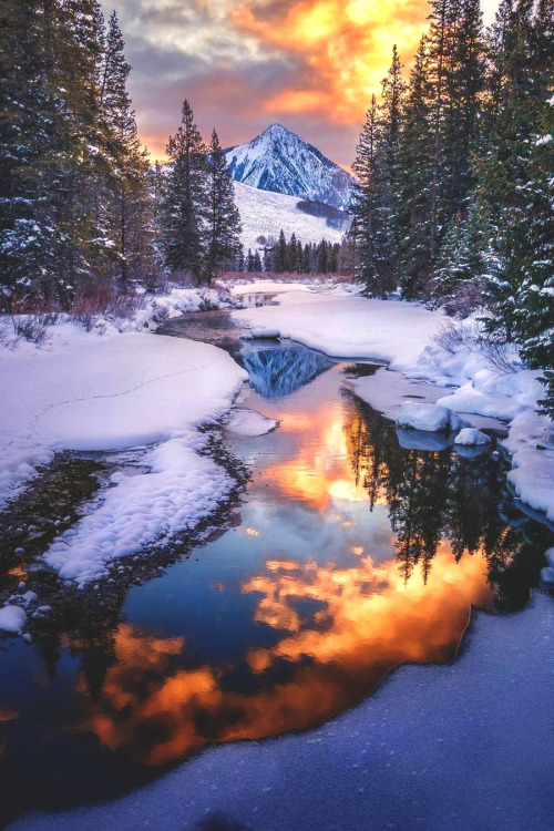
Mirror mirror on the wall... ☀️ | connography_
Location: Crested Butte, Colorado, USA

River Bends Through 1,000-Foot Canyons
An astronaut aboard the International Space Station shot this photograph of the Green River flowing through deep, red rock canyons in eastern Utah. A main tributary of the Colorado River, the Green flows 730 miles (1,175 kilometers) through Wyoming, Colorado and Utah. The portion of the Green River in this image is just north of Canyonlands National Park.
Bowknot Bend was named for the way the river loops back on itself. Located in Labyrinth Canyon about 25 miles west of Moab, Utah, this river bend runs 7.5 miles (12 kilometers) in a circular loop and ends up 1,200 feet (360 meters) from where it first started. When the two sides of the river merge someday, Bowknot Bend will break off from the main channel and form a lake.
Read more: https://go.nasa.gov/2OMANak
Make sure to follow us on Tumblr for your regular dose of space: http://nasa.tumblr.com.


Shoshone Falls
-
 goodpointsandbadpoints liked this · 1 year ago
 -
 crafting-system reblogged this · 3 years ago
 -
 diaryofatherapist reblogged this · 4 years ago
 -
 anorexicwithagodcomex liked this · 4 years ago
 -
 hopewanes liked this · 4 years ago
 -
 the-nerdy-bookworm liked this · 4 years ago
 -
 autisticdrizzt reblogged this · 4 years ago
 -
 wild--irish--rose liked this · 4 years ago
 -
 schizorexia liked this · 4 years ago
 -
 letspantarhei liked this · 4 years ago
 -
 notmanthelessbutnaturemore liked this · 4 years ago
 -
 jadrankaromeo liked this · 4 years ago
 -
 astr0gay liked this · 4 years ago
 -
 cessairart liked this · 4 years ago
 -
 always-laugh-it-out-39 reblogged this · 4 years ago
 -
 justbreezy18 reblogged this · 4 years ago
 -
justbreezy18 liked this · 4 years ago
-
 lgbtq-nightmare liked this · 4 years ago
 -
 disappearingcass reblogged this · 4 years ago
 -
 xvirginsuicides liked this · 4 years ago
 -
 aceyanaheim liked this · 4 years ago
 -
 lxremipsumm liked this · 4 years ago
 -
 tobesuchafreak liked this · 4 years ago
 -
 theeastsideoflife liked this · 4 years ago
 -
 kalopsio44 reblogged this · 4 years ago
 -
kalopsio44 liked this · 4 years ago
-
 bloodcreme liked this · 4 years ago
 -
 brains-r-cool liked this · 4 years ago
 -
lxremipsumm reblogged this · 4 years ago
-
 nadinetossi liked this · 5 years ago
 -
 questshunself reblogged this · 5 years ago
 -
 mylifebelike729 liked this · 5 years ago
 -
 valengory1234 liked this · 5 years ago
 -
 sapphoglitter liked this · 5 years ago
 -
 jimipoo liked this · 5 years ago
 -
 doitforscooby reblogged this · 5 years ago
 -
 juniper-berryy liked this · 5 years ago
 -
 foggyfishlampghost liked this · 5 years ago
 -
 purplemanatees liked this · 5 years ago
 -
 weepingbouquettyphoon reblogged this · 5 years ago
 -
weepingbouquettyphoon liked this · 5 years ago
-
 artichokefartichoke reblogged this · 5 years ago

30. she|her|hers. montrose, colorado, or the side of the state no one knows about. originally from washington dc social worker, obsessed with my dog, mountains....
219 posts