Fillthevoid-with-space - Fill The Void With... SPACE

More Posts from Fillthevoid-with-space and Others

Scientists Discover The Oldest, Largest Body Of Water In Existence–In Space
Scientists have found the biggest and oldest reservoir of water ever–so large and so old, it’s almost impossible to describe.
The water is out in space, a place we used to think of as desolate and desert dry, but it’s turning out to be pretty lush.
Researchers found a lake of water so large that it could provide each person on Earth an entire planet’s worth of water–20,000 times over. Yes, so much water out there in space that it could supply each one of us all the water on Earth–Niagara Falls, the Pacific Ocean, the polar ice caps, the puddle in the bottom of the canoe you forgot to flip over–20,000 times over.
The water is in a cloud around a huge black hole that is in the process of sucking in matter and spraying out energy (such an active black hole is called a quasar), and the waves of energy the black hole releases make water by literally knocking hydrogen and oxygen atoms together.
The official NASA news release describes the amount of water as “140 trillion times all the water in the world’s oceans,“ which isn’t particularly helpful, except if you think about it like this.
That one cloud of newly discovered space water vapor could supply 140 trillion planets that are just as wet as Earth is.
Mind you, our own galaxy, the Milky Way, has about 400 billion stars, so if every one of those stars has 10 planets, each as wet as Earth, that’s only 4 trillion planets worth of water.
The new cloud of water is enough to supply 28 galaxies with water.
Truly, that is one swampy patch of intergalactic space.
Equally stunning is the age of the water factory. The two teams of astrophysicists that found the quasar were looking out in space a distance of 12 billion light years. That means they were also looking back in time 12 billion years, to when the universe itself was just 1.6 billion years old. They were watching water being formed at the very start of the known universe, which is to say, water was one of the first substances formed, created in galactic volumes from the earliest time. Given water’s creative power to shape geology, climate and biology, that’s dramatic.
“It’s another demonstration that water is pervasive throughout the universe, even at the very earliest times,” says Matt Bradford, an astrophysicist at NASA’s Jet Propulsion Laboratory and leader of one of the teams that made the discovery. (The journal article reporting the discovery is titled, without drama, “The Water Vapor Spectrum of APM 08279+5255: X-Ray Heating and Infrared Pumping over Hundreds of Parsecs.”)
It is not as if you’d have to wear foul-weather gear if you could visit this place in space, however. The distances are as mind-bogglingly large as the amount of water being created, so the water vapor is the finest mist–300 trillion times less dense than the air in a typical room.
And it’s not as if this intergalactic water can be of any use to us here on Earth, of course, at least not in the immediate sense. Indeed, the discovery comes as a devastating drought across eastern Africa is endangering the lives of 10 million people in Somalia, Kenya, and Ethiopia. NASA’s water discovery should be a reminder that if we have the sophistication to discover galaxies full of water 12 billion light years away, we should be able to save people just an ocean away from drought-induced starvation.
The NASA announcement is also a reminder how quickly our understanding of the universe is evolving and how much capacity for surprise nature still has for us. There’s water on Mars, there’s water jetting hundreds of miles into space from Enceladus, one of Saturn’s moons, there are icebergs of water hidden in the polar craters of our own Moon. And now it turns out that a single quasar has the ability to manufacture galaxies full of water.
But it was only 40 years ago, in 1969, that scientists first confirmed that water existed anywhere besides Earth.
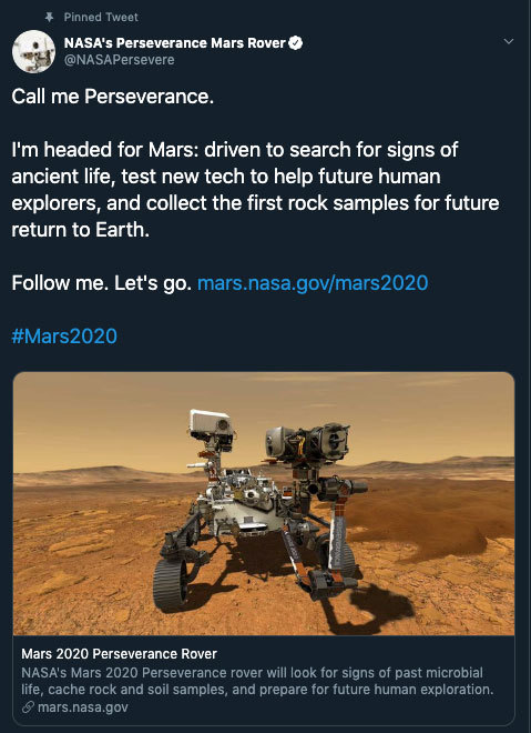
Allow us to reintroduce someone … the name’s Perseverance.
With this new name, our Mars 2020 rover has now come to life! Chosen by middle school student Alex Mather, Perseverance helps to remind ourselves that no matter what obstacles we face, whether it’s on the way to reaching our goals or on the way to Mars, we will push through. In Alex’s own words,
“We are a species of explorers, and we will meet many setbacks on the way to Mars. However, we can persevere. We, not as a nation but as humans, will not give up. The human race will always persevere into the future.”
Welcome to the family. ❤️
Make sure to follow us on Tumblr for your regular dose of space: http://nasa.tumblr.com.

Yes, sure its fun to see a lady spin around like that, but I had one of my friends ask me - “Where do you even use this mate?”
Here’s one application that I know very well off.
Spin Stabilization
If you have ever seen a rocket launch, you might know that sometimes the rockets are given a spin while launching. This is known as spin stabilization.

Basically, the rotational inertia of the rotating body will stabilize the rocket against any disturbances and help maintain its intended heading.
The same principle is used in rifling of firearms as well. **

YoYo DeSpin
Okay, now there is the question how to “De-spin” the rocket:
Well, you do what the lady does: stretch out your arms and you will slow down !

The rocket has weights connected to a cable that stretch out and almost immediately the rocket slows down. This maneuver is known as the YoYo DeSpin. ( Damn good name ! )
All thanks to the conservation of angular momentum !
Have a good one !
* Another method to stabilization : 3-axis stabilization
** Bullets spin stabilization - post
** Source rocket launch video


Happy Labor Day. Today I learned about probably the first strike to happen IN SPACE.

ASTROGENOUS
[adjective]
producing or creating stars.
Etymology: from Greek, from astron “star” + -genēs “born”.
[J. R. Slattum - Star Maker]
Gotta wake up pretty early in the morning to see the blue blood moon!

SUPER BLUE BLOOD MOON
How does a microgravity garden grow when there’s no up or down? An advanced chamber, about the size of a mini-fridge, is giving us a clearer perspective of plant growth habits. Without gravity and the addition of a wide variety of light and humidity settings, the plants cultivated on the International Space Station provide a world of opportunity to study space-based agricultural cycles.
Learn more about our space garden HERE.
Make sure to follow us on Tumblr for your regular dose of space: http://nasa.tumblr.com
Celebrating 17 Years of NASA’s ‘Little Earth Satellite That Could’
The satellite was little— the size of a small refrigerator; it was only supposed to last one year and constructed and operated on a shoestring budget — yet it persisted.
After 17 years of operation, more than 1,500 research papers generated and 180,000 images captured, one of NASA’s pathfinder Earth satellites for testing new satellite technologies and concepts comes to an end on March 30, 2017. The Earth Observing-1 (EO-1) satellite will be powered off on that date but will not enter Earth’s atmosphere until 2056.
“The Earth Observing-1 satellite is like The Little Engine That Could,” said Betsy Middleton, project scientist for the satellite at NASA’s Goddard Space Flight Center in Greenbelt, Maryland.
To celebrate the mission, we’re highlighting some of EO-1’s notable contributions to scientific research, spaceflight advancements and society.
Scientists Learn More About Earth in Fine Detail

This animation shifts between an image showing flooding that occurred at the Arkansas and Mississippi rivers on January 12, 2016, captured by ALI and the rivers at normal levels on February 14, 2015 taken by the Operational Land Imager on Landsat 8. Credit: NASA’s Earth Observatory
EO-1 carried the Advanced Land Imager that improved observations of forest cover, crops, coastal waters and small particles in the air known as aerosols. These improvements allowed researchers to identify smaller features on a local scale such as floods and landslides, which were especially useful for disaster support.

On the night of Sept. 6, 2014, EO-1’s Hyperion observed the ongoing eruption at Holuhraun, Iceland as shown in the above image. Partially covered by clouds, this scene shows the extent of the lava flows that had been erupting.
EO-1’s other key instrument Hyperion provided an even greater level of detail in measuring the chemical constituents of Earth’s surface— akin to going from a black and white television of the 1940s to the high-definition color televisions of today. Hyperion’s level of sophistication doesn’t just show that plants are present, but can actually differentiate between corn, sorghum and many other species and ecosystems. Scientists and forest managers used these data, for instance, to explore remote terrain or to take stock of smoke and other chemical constituents during volcanic eruptions, and how they change through time.
Crowdsourced Satellite Images of Disasters

EO-1 was one of the first satellites to capture the scene after the World Trade Center attacks (pictured above) and the flooding in New Orleans after Hurricane Katrina. EO-1 also observed the toxic sludge in western Hungary in October 2010 and a large methane leak in southern California in October 2015. All of these scenes, which EO-1 provided quick, high-quality satellite imagery of the event, were covered in major news outlets. All of these scenes were also captured because of user requests. EO-1 had the capability of being user-driven, meaning the public could submit a request to the team for where they wanted the satellite to gather data along its fixed orbits.

This image shows toxic sludge (red-orange streak) running west from an aluminum oxide plant in western Hungary after a wall broke allowing the sludge to spill from the factory on October 4, 2010. This image was taken by EO-1’s Advanced Land Imager on October 9, 2010. Credit: NASA’s Earth Observatory
Artificial Intelligence Enables More Efficient Satellite Collaboration

This image of volcanic activity on Antarctica’s Mount Erebus on May 7, 2004 was taken by EO-1’s Advanced Land Imager after sensing thermal emissions from the volcano. The satellite gave itself new orders to take another image several hours later. Credit: Earth Observatory
EO-1 was among the first satellites to be programmed with a form of artificial intelligence software, allowing the satellite to make decisions based on the data it collects. For instance, if a scientist commanded EO-1 to take a picture of an erupting volcano, the software could decide to automatically take a follow-up image the next time it passed overhead. The Autonomous Sciencecraft Experiment software was developed by NASA’s Jet Propulsion Laboratory in Pasadena, California, and was uploaded to EO-1 three years after it launched.

This image of Nassau Bahamas was taken by EO-1’s Advanced Land Imager on Oct 8, 2016, shortly after Hurricane Matthew hit. European, Japanese, Canadian, and Italian Space Agency members of the international coalition Committee on Earth Observation Satellites used their respective satellites to take images over the Caribbean islands and the U.S. Southeast coastline during Hurricane Matthew. Images were used to make flood maps in response to requests from disaster management agencies in Haiti, Dominican Republic, St. Martin, Bahamas, and the U.S. Federal Emergency Management Agency.
The artificial intelligence software also allows a group of satellites and ground sensors to communicate and coordinate with one another with no manual prompting. Called a “sensor web”, if a satellite viewed an interesting scene, it could alert other satellites on the network to collect data during their passes over the same area. Together, they more quickly observe and downlink data from the scene than waiting for human orders. NASA’s SensorWeb software reduces the wait time for data from weeks to days or hours, which is especially helpful for emergency responders.
Laying the Foundation for ‘Formation Flying’

This animation shows the Rodeo-Chediski fire on July 7, 2002, that were taken one minute apart by Landsat 7 (burned areas in red) and EO-1 (burned areas in purple). This precision formation flying allowed EO-1 to directly compare the data and performance from its land imager and the Landsat 7 ETM+. EO-1’s most important technology goal was to test ALI for future Landsat satellites, which was accomplished on Landsat 8. Credit: NASA’s Goddard Space Flight Center
EO-1 was a pioneer in precision “formation flying” that kept it orbiting Earth exactly one minute behind the Landsat 7 satellite, already in orbit. Before EO-1, no satellite had flown that close to another satellite in the same orbit. EO-1 used formation flying to do a side-by-side comparison of its onboard ALI with Landsat 7’s operational imager to compare the products from the two imagers. Today, many satellites that measure different characteristics of Earth, including the five satellites in NASA’s A Train, are positioned within seconds to minutes of one another to make observations on the surface near-simultaneously.
For more information on EO-1’s major accomplishments, visit: https://www.nasa.gov/feature/goddard/2017/celebrating-17-years-of-nasa-s-little-earth-satellite-that-could
Make sure to follow us on Tumblr for your regular dose of space: http://nasa.tumblr.com/.
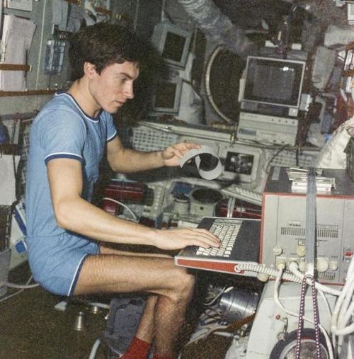
Soviet Cosmonaut Sergei Krikalev stuck in space during the collapse of the Soviet Union in 1991
Unable to return home, he ended up having to stay in space until further notice.
The cosmonaut eventually returned back to earth on March 25, 1992, after 10 months in orbit - to a nation that was very different to what it was when he had left. The Soviet Union had fractured into 15 nations, presidents had changed, and even his hometown of Leningrad had become St. Petersburg.
Interestingly, at the time, Krikalev was supposed to serve in the military reserves, and was almost issued a warrant for desertion – before the army realised that their reserve soldier was not even on the planet.
-
 provokingimagination reblogged this · 2 weeks ago
 -
 cottagecrowe liked this · 1 year ago
 -
 dailymusemaniac reblogged this · 2 years ago
 -
 anclarare-blog liked this · 2 years ago
 -
 simplyyell0w liked this · 2 years ago
 -
 always-over-looked reblogged this · 3 years ago
 -
always-over-looked liked this · 3 years ago
-
 ohwander liked this · 4 years ago
 -
 assholewithoutadick liked this · 4 years ago
 -
 blaquevamp reblogged this · 4 years ago
 -
blaquevamp liked this · 4 years ago
-
 rainsys liked this · 4 years ago
 -
 dreamingofmorpheus reblogged this · 4 years ago
 -
 sinn1230 liked this · 4 years ago
 -
 wistful-wonder liked this · 4 years ago
 -
 artemissa liked this · 4 years ago
 -
 snflwrposty liked this · 4 years ago
 -
 r-xela01 liked this · 4 years ago
 -
 lowbatteryinthehollywoodhills liked this · 4 years ago
 -
 clockspur liked this · 4 years ago
 -
 wisdomfromacrazyperson reblogged this · 4 years ago
 -
 thespookygoose liked this · 4 years ago
 -
 mayonguyen liked this · 4 years ago
 -
 smokeandmunch liked this · 4 years ago
 -
 unimaginablefloaters reblogged this · 4 years ago
 -
 kingminos3 liked this · 4 years ago
 -
 hearthesirencall reblogged this · 4 years ago
 -
 landsurfingpro liked this · 4 years ago
 -
 6thsensical liked this · 4 years ago
 -
 jloistic liked this · 4 years ago
 -
 i-sat-bythe0cean liked this · 4 years ago
 -
 analu-dreamer liked this · 5 years ago
 -
 time-does-not-bring-relief reblogged this · 5 years ago
 -
 voidofcourse8 liked this · 5 years ago
 -
 whatthefrickfrack16 liked this · 5 years ago
 -
provokingimagination liked this · 5 years ago
-
 taelosian reblogged this · 5 years ago
 -
 cozystayawhile reblogged this · 5 years ago
 -
 dutchfruitjar reblogged this · 5 years ago
 -
dutchfruitjar liked this · 5 years ago
-
 karinajimenez14 liked this · 5 years ago
A podcast project to fill the space in my heart and my time that used to be filled with academic research. In 2018, that space gets filled with... MORE SPACE! Cheerfully researched, painstakingly edited, informal as hell, definitely worth everyone's time.
243 posts