Rolling Skies

Rolling Skies
More Posts from Spinatlasagne-blog and Others


harkonnen ornithopter sketches inspired by artofthera https://www.artstation.com/artwork/QWOJr


Cool Space GIFs from the Internet
There’s a lot of historical and archived space footage on the internet and we’re excited to see that the public (you!) have taken it to create many other products that teach people about exploration, space and our universe. Among those products are GIFs. Those quick videos that help you express what you’re trying to say via text, or make you laugh while surfing the web.
Are space GIFs the new cat videos of the internet? Don’t know, but we sure do like them!
Here are a few neat space GIFs from the internet…
This GIF of the Cat Eye Nebula shows it in various wavelengths…

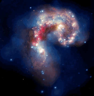
Followed by a GIF of a cat in space…floating in front of the Antennae galaxies…
One time, a frog actually photobombed the launch of our LADEE spacecraft…someone on the internet gave him a parachute…

Want to see what it’s like to play soccer in space? There’s a GIF for that…

There are also some beautiful GIFs looking through the Cupola window on the International Space Station…


This warped footage from the International Space Station gives us ride around the Earth…

While this one encourages us to explore the unknown…

When our New Horizons spacecraft flew by dwarf planet Pluto in 2015, the internet couldn’t get enough of the Pluto GIFs…

NASA GIFs

Want to dive into a black hole of other fun space GIFs? Check out our GIPHY page HERE.
Want to use our GIFs?! You can! Our GIFs are accessible directly from the Twitter app. Just tap or click the GIF button in the Twitter tool bar, search for NASAGIF, and all NASA GIFs will appear for sharing and tweeting. Enjoy!
GIF Sources
Cat Eye GIF: https://giphy.com/gifs/astronomy-cZpDWjSlKjWPm Cat GIF: https://giphy.com/gifs/cat-HopYL0SamcCli Frog GIF: https://giphy.com/gifs/nasa-photo-rocket-NOsCSDT2rUgfK Soccer GIF: https://giphy.com/gifs/yahoo-astronauts-zerogravity-QF1ZomA11zofC Cupola 1 GIF: https://giphy.com/gifs/nasa-Mcoxp6TgvQm6A Cupola 2 GIF: https://giphy.com/gifs/timelapse-space-11f3o8D2rQWzCM Earth GIF: http://giphy.com/gifs/earth-milky-way-international-space-station-ONC6WgECm5KEw Explore GIF: https://giphy.com/gifs/text-timelapse-lapse-Vj7gwAvhgsDYs Pluto 1 GIF: https://giphy.com/gifs/l46CzjUnYFfeMXiNO Pluto 2 GIF: https://giphy.com/gifs/pluto-dbV1LkFWWob84
Make sure to follow us on Tumblr for your regular dose of space: http://nasa.tumblr.com

Eight Small Satellites Will Give Us a New Look Inside Hurricanes

The same GPS technology that helps people get where they’re going in a car will soon be used in space in an effort to improve hurricane forecasting. The technology is a key capability in a NASA mission called the Cyclone Global Navigation Satellite System (CYGNSS).

The CYGNSS mission, led by the University of Michigan, will use eight micro-satellite observatories to measure wind speeds over Earth’s oceans, increasing the ability of scientists to understand and predict hurricanes. Each microsatellite observatory will make observations based on the signals from four GPS satellites.

The CYGNSS microsatellite observatories will only receive signals broadcast directly to them from GPS satellites already orbiting the Earth and the reflection of the same satellite’s signal reflected from the Earth’s surface. The CYGNSS satellites themselves will not broadcast.

The use of eight microsatellite observatories will decrease the revisit time as compared with current individual weather satellites. The spacecraft will be deployed separately around the planet, with successive satellites passing over the same region every 12 minutes.
This will be the first time that satellites can peer through heavy tropical rainfall into the middle of hurricanes and predict how intense they are before and during landfall.

As the CYGNSS and GPS constellations orbit around the Earth, the interaction of the two systems will result in a new image of wind speed over the entire tropics every few hours, compared to every few days for a single satellite.

Another advantage of CYGNSS is that its orbit is designed to measure only in the tropics…where hurricanes develop and are most often located. The focus on tropical activity means that the instruments will be able to gather much more useful data on weather systems exclusively found in the tropics. This data will ultimately be used to help forecasters and emergency managers make lifesaving decisions.
Launch!

CYGNSS launched at 8:37 a.m. EST on Thursday, Dec. 15, from our Kennedy Space Center in Florida. CYGNSS launched aboard an Orbital ATK Pegasus XL rocket, deployed from Orbital’s “Stargazer” L-1011 carrier aircraft.
Pegasus is a winged, three-stage solid propellant rocket that can launch a satellite into low Earth orbit. How does it work? Great question!

After takeoff, the aircraft (which looks like a commercial airplane..but with some special quirks) flies to about 39,000 feet over the ocean and releases the rocket.

After a five-second free fall in a horizontal position, the Pegasus first stage ignites. The aerodynamic lift, generated by the rocket’s triangle-shaped wing, delivers the payload into orbit in about 10 minutes.
Pegasus is used to deploy small satellites weighing up to 1,000 pounds into low Earth orbit.
And success! The eight CYGNSS satellites were successfully deployed into orbit!
Make sure to follow us on Tumblr for your regular dose of space: http://nasa.tumblr.com
Astronomy From 45,000 Feet
What is the Stratospheric Observatory for Infrared Astronomy, or SOFIA, up to?

SOFIA, the Stratospheric Observatory for Infrared Astronomy, as our flying telescope is called, is a Boeing 747SP aircraft that carries a 2.5-meter telescope to altitudes as high as 45,000 feet. Researchers use SOFIA to study the solar system and beyond using infrared light. This type of light does not reach the ground, but does reach the altitudes where SOFIA flies.

Recently, we used SOFIA to study water on Venus, hoping to learn more about how that planet lost its oceans. Our researchers used a powerful instrument on SOFIA, called a spectrograph, to detect water in its normal form and “heavy water,” which has an extra neutron. The heavy water takes longer to evaporate and builds up over time. By measuring how much heavy water is on Venus’ surface now, our team will be able to estimate how much water Venus had when the planet formed.

We are also using SOFIA to create a detailed map of the Whirlpool Galaxy by making multiple observations of the galaxy. This map will help us understand how stars form from clouds in that galaxy. In particular, it will help us to know if the spiral arms in the galaxy trigger clouds to collapse into stars, or if the arms just show up where stars have already formed.

We can also use SOFIA to study methane on Mars. The Curiosity rover has detected methane on the surface of Mars. But the total amount of methane on Mars is unknown and evidence so far indicates that its levels change significantly over time and location. We are using SOFIA to search for evidence of this gas by mapping the Red Planet with an instrument specially tuned to sniff out methane.

The plumes, illustrated in the artist’s concept above, were previously seen in images as extensions from the edge of the moon. Next our team will use SOFIA to study Jupiter’s icy moon Europa, searching for evidence of possible water plumes detected by the Hubble Space Telescope. The plumes were previously seen in images as extensions from the edge of the moon. Using SOFIA, we will search for water and determine if the plumes are eruptions of water from the surface. If the plumes are coming from the surface, they may be erupting through cracks in the ice that covers Europa’s oceans. Members of our SOFIA team recently discussed studying Europa on the NASA in Silicon Valley Podcast.

This is the view of Jupiter and its moons taken with SOFIA’s visible light guide camera that is used to position the telescope.
Make sure to follow us on Tumblr for your regular dose of space: http://nasa.tumblr.com

ART: “Early Morning” by Jan van de Klooster


-
 estrellitadelnorte liked this · 1 year ago
 -
 pixie-styx liked this · 2 years ago
 -
 pixie-styx-mix reblogged this · 2 years ago
 -
 cinn4mongrl liked this · 4 years ago
 -
 daydreamers-arelost reblogged this · 4 years ago
 -
 coreyhammy liked this · 5 years ago
 -
 yulis-lemman liked this · 5 years ago
 -
 nevereverdecaf liked this · 6 years ago
 -
 rodolfo9999 liked this · 6 years ago
 -
 sumbluespruce liked this · 6 years ago
 -
 dstroyerradio liked this · 6 years ago
 -
 barbaranestor2 liked this · 6 years ago
 -
 babu-r-itsme-blog liked this · 6 years ago
 -
 jimmicisme liked this · 6 years ago
 -
 julietterainbow liked this · 6 years ago
 -
 lifeofawriterphotographer liked this · 6 years ago
 -
 tammyfeabakker reblogged this · 6 years ago
 -
tammyfeabakker liked this · 6 years ago
-
 doctordearie reblogged this · 6 years ago
 -
doctordearie liked this · 6 years ago
-
 rainbowlady53 liked this · 6 years ago
 -
 kerovous liked this · 6 years ago
 -
 warxpunkxmonk liked this · 6 years ago
 -
 fotoitalien liked this · 6 years ago
 -
 ji11ian1 reblogged this · 6 years ago
 -
ji11ian1 liked this · 6 years ago
-
 nowayasock reblogged this · 6 years ago
 -
 kid-adonis0812 liked this · 6 years ago
 -
 sketchycatt liked this · 6 years ago
 -
 serendipitousramblings liked this · 7 years ago
 -
 iantoons liked this · 7 years ago
 -
 endless-and-serpentine liked this · 7 years ago
 -
 miss-omniscientus liked this · 7 years ago
 -
 catmasterfunk liked this · 7 years ago