Here's A Better Breakdown Of How Records Work! With A Video, Even!
Here's a better breakdown of how records work! With a video, even!

Electron microscope video of a needle on a vinyl record.
More Posts from Fillthevoid-with-space and Others


When the sun sets on Stonehenge on the shortest day of the year, it’s rays align with several important stones. Twice a year, the streets of Manhattan also line up with the setting sun, a phenomenon dubbed “Manhattanhenge”. Really, most cities with grid systems will see a similar effect (though it’s most dramatic in cities with tall buildings and a view of the true horizon). You can use a great tool called The Photographer’s Ephemeris to find out the “henge” dates for your city grid - or even individual streets.
Yesterday, (Friday, January 24th) the sun lined up with New York Avenue, a street in DC that runs diagonally up to the White House. (The orange line indicates alignment with the setting sun).
I went out with our multimedia intern Meg Vogel, and captured some images of the sun setting in line with a rather Stonehenge-y sculpture that sits in the middle of that street.
Here are dates for sunset “henge” events in some cities this year:
Manhattan May 25th, July 17th
Philadelphia April 5th, September 6th
Washington DC March 18th, September 24th
Chicago March 16th, September 26th
Phoenix March 20th, September 22nd
Portland, OR March 18th, September 24th
Is your city/town a grid? When’s your henge?


It’s way too late for this, but it’s important to note that NASA didn’t discover the new earth-like planets. It was a group of astronomers lead by a dude name Michaël Gillon from the University of Liège in Belgium. Giving NASA credit for this gives the United States credit for something they didn’t do, and we already have a problem with making things about ourselves so. just like…be mindful. I’d be pissed if I discovered a small solar system and credit was wrongfully given to someone else.


After spending a month attached to the ISS, the Dragon spacecraft succesfully lands in the pacific and is shipped back to land.
via reddit
Celebrating 17 Years of NASA’s ‘Little Earth Satellite That Could’
The satellite was little— the size of a small refrigerator; it was only supposed to last one year and constructed and operated on a shoestring budget — yet it persisted.
After 17 years of operation, more than 1,500 research papers generated and 180,000 images captured, one of NASA’s pathfinder Earth satellites for testing new satellite technologies and concepts comes to an end on March 30, 2017. The Earth Observing-1 (EO-1) satellite will be powered off on that date but will not enter Earth’s atmosphere until 2056.
“The Earth Observing-1 satellite is like The Little Engine That Could,” said Betsy Middleton, project scientist for the satellite at NASA’s Goddard Space Flight Center in Greenbelt, Maryland.
To celebrate the mission, we’re highlighting some of EO-1’s notable contributions to scientific research, spaceflight advancements and society.
Scientists Learn More About Earth in Fine Detail

This animation shifts between an image showing flooding that occurred at the Arkansas and Mississippi rivers on January 12, 2016, captured by ALI and the rivers at normal levels on February 14, 2015 taken by the Operational Land Imager on Landsat 8. Credit: NASA’s Earth Observatory
EO-1 carried the Advanced Land Imager that improved observations of forest cover, crops, coastal waters and small particles in the air known as aerosols. These improvements allowed researchers to identify smaller features on a local scale such as floods and landslides, which were especially useful for disaster support.

On the night of Sept. 6, 2014, EO-1’s Hyperion observed the ongoing eruption at Holuhraun, Iceland as shown in the above image. Partially covered by clouds, this scene shows the extent of the lava flows that had been erupting.
EO-1’s other key instrument Hyperion provided an even greater level of detail in measuring the chemical constituents of Earth’s surface— akin to going from a black and white television of the 1940s to the high-definition color televisions of today. Hyperion’s level of sophistication doesn’t just show that plants are present, but can actually differentiate between corn, sorghum and many other species and ecosystems. Scientists and forest managers used these data, for instance, to explore remote terrain or to take stock of smoke and other chemical constituents during volcanic eruptions, and how they change through time.
Crowdsourced Satellite Images of Disasters

EO-1 was one of the first satellites to capture the scene after the World Trade Center attacks (pictured above) and the flooding in New Orleans after Hurricane Katrina. EO-1 also observed the toxic sludge in western Hungary in October 2010 and a large methane leak in southern California in October 2015. All of these scenes, which EO-1 provided quick, high-quality satellite imagery of the event, were covered in major news outlets. All of these scenes were also captured because of user requests. EO-1 had the capability of being user-driven, meaning the public could submit a request to the team for where they wanted the satellite to gather data along its fixed orbits.

This image shows toxic sludge (red-orange streak) running west from an aluminum oxide plant in western Hungary after a wall broke allowing the sludge to spill from the factory on October 4, 2010. This image was taken by EO-1’s Advanced Land Imager on October 9, 2010. Credit: NASA’s Earth Observatory
Artificial Intelligence Enables More Efficient Satellite Collaboration

This image of volcanic activity on Antarctica’s Mount Erebus on May 7, 2004 was taken by EO-1’s Advanced Land Imager after sensing thermal emissions from the volcano. The satellite gave itself new orders to take another image several hours later. Credit: Earth Observatory
EO-1 was among the first satellites to be programmed with a form of artificial intelligence software, allowing the satellite to make decisions based on the data it collects. For instance, if a scientist commanded EO-1 to take a picture of an erupting volcano, the software could decide to automatically take a follow-up image the next time it passed overhead. The Autonomous Sciencecraft Experiment software was developed by NASA’s Jet Propulsion Laboratory in Pasadena, California, and was uploaded to EO-1 three years after it launched.

This image of Nassau Bahamas was taken by EO-1’s Advanced Land Imager on Oct 8, 2016, shortly after Hurricane Matthew hit. European, Japanese, Canadian, and Italian Space Agency members of the international coalition Committee on Earth Observation Satellites used their respective satellites to take images over the Caribbean islands and the U.S. Southeast coastline during Hurricane Matthew. Images were used to make flood maps in response to requests from disaster management agencies in Haiti, Dominican Republic, St. Martin, Bahamas, and the U.S. Federal Emergency Management Agency.
The artificial intelligence software also allows a group of satellites and ground sensors to communicate and coordinate with one another with no manual prompting. Called a “sensor web”, if a satellite viewed an interesting scene, it could alert other satellites on the network to collect data during their passes over the same area. Together, they more quickly observe and downlink data from the scene than waiting for human orders. NASA’s SensorWeb software reduces the wait time for data from weeks to days or hours, which is especially helpful for emergency responders.
Laying the Foundation for ‘Formation Flying’

This animation shows the Rodeo-Chediski fire on July 7, 2002, that were taken one minute apart by Landsat 7 (burned areas in red) and EO-1 (burned areas in purple). This precision formation flying allowed EO-1 to directly compare the data and performance from its land imager and the Landsat 7 ETM+. EO-1’s most important technology goal was to test ALI for future Landsat satellites, which was accomplished on Landsat 8. Credit: NASA’s Goddard Space Flight Center
EO-1 was a pioneer in precision “formation flying” that kept it orbiting Earth exactly one minute behind the Landsat 7 satellite, already in orbit. Before EO-1, no satellite had flown that close to another satellite in the same orbit. EO-1 used formation flying to do a side-by-side comparison of its onboard ALI with Landsat 7’s operational imager to compare the products from the two imagers. Today, many satellites that measure different characteristics of Earth, including the five satellites in NASA’s A Train, are positioned within seconds to minutes of one another to make observations on the surface near-simultaneously.
For more information on EO-1’s major accomplishments, visit: https://www.nasa.gov/feature/goddard/2017/celebrating-17-years-of-nasa-s-little-earth-satellite-that-could
Make sure to follow us on Tumblr for your regular dose of space: http://nasa.tumblr.com/.
New Horizons Flyover of Pluto
Using actual New Horizons data and digital elevation models of Pluto and its largest moon Charon, mission scientists have created flyover movies that offer spectacular new perspectives of the many unusual features that were discovered and which have reshaped our views of the Pluto system – from a vantage point even closer than the spacecraft itself. This dramatic Pluto flyover begins over the highlands to the southwest of the great expanse of nitrogen ice plain informally named Sputnik Planitia. The viewer first passes over the western margin of Sputnik, where it borders the dark, cratered terrain of Cthulhu Macula, with the blocky mountain ranges located within the plains seen on the right. The tour moves north past the rugged and fractured highlands of Voyager Terra and then turns southward over Pioneer Terra – which exhibits deep and wide pits – before concluding over the bladed terrain of Tartarus Dorsa in the far east of the encounter hemisphere. Digital mapping and rendering were performed by Paul Schenk and John Blackwell of the Lunar and Planetary Institute in Houston.


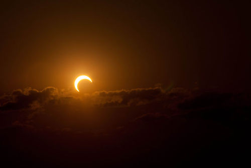

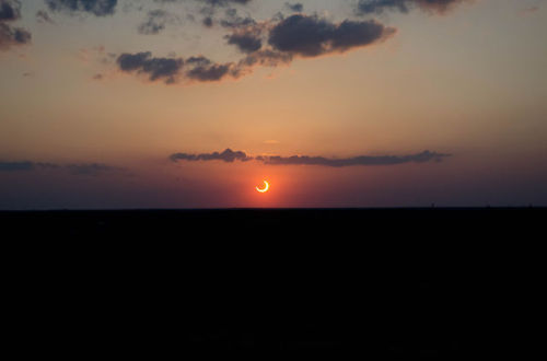


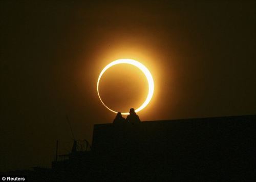
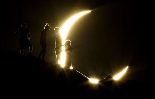
A ‘Ring of Fire’ solar eclipse is a rare phenomenon that occurs when the moon’s orbit is at its apogee: the part of its orbit farthest away from the Earth. Because the moon is so far away, it seems smaller than normal to the human eye. The result is that the moon doesn't entirely block out our view of the sun, but leaves an “annulus,” or ring of sunlight glowing around it. Hence the term “annular” eclipse rather than a “total” eclipse.
-
 distortionenby liked this · 1 month ago
 -
 winterzworld liked this · 1 month ago
 -
 blogforfavethings reblogged this · 1 month ago
 -
 purplemuricidae reblogged this · 1 month ago
 -
 yblue-045 liked this · 1 month ago
 -
 functiondys liked this · 1 month ago
 -
 phantomlemon348 reblogged this · 1 month ago
 -
phantomlemon348 liked this · 1 month ago
-
 shadowcats4 reblogged this · 1 month ago
 -
shadowcats4 liked this · 1 month ago
-
 aweekoftodays liked this · 1 month ago
 -
 interludesanddaydreams reblogged this · 1 month ago
 -
interludesanddaydreams liked this · 1 month ago
-
purplemuricidae liked this · 1 month ago
-
 arbrehoux reblogged this · 1 month ago
 -
arbrehoux liked this · 1 month ago
-
 iconic-bi-bitch reblogged this · 1 month ago
 -
iconic-bi-bitch liked this · 1 month ago
-
 discoleo liked this · 1 month ago
 -
 serenagold reblogged this · 1 month ago
 -
 mangocatuwu reblogged this · 1 month ago
 -
mangocatuwu liked this · 1 month ago
-
 minishimi liked this · 1 month ago
 -
 bambi666 liked this · 2 months ago
 -
 luxiapoof42 reblogged this · 2 months ago
 -
 mockingbird32 reblogged this · 2 months ago
 -
 lynx-of-storms reblogged this · 2 months ago
 -
lynx-of-storms liked this · 2 months ago
-
 i-see-7-cats reblogged this · 2 months ago
 -
 poeticallydisgraced liked this · 2 months ago
 -
 apollosdrunkenmixup reblogged this · 2 months ago
 -
apollosdrunkenmixup liked this · 2 months ago
-
 challahback-boy reblogged this · 2 months ago
 -
challahback-boy liked this · 2 months ago
-
 computermuncher reblogged this · 2 months ago
 -
 dooptyymarkypoopy reblogged this · 2 months ago
 -
dooptyymarkypoopy liked this · 2 months ago
-
 tealballoonzombie liked this · 2 months ago
 -
 clownaddict reblogged this · 2 months ago
 -
 warfangwhowrote reblogged this · 2 months ago
 -
 hypnoticpolkadots liked this · 2 months ago
 -
 ed15000 liked this · 2 months ago
 -
 c-qcat reblogged this · 2 months ago
 -
c-qcat liked this · 2 months ago
-
 deranged-kai reblogged this · 2 months ago
 -
deranged-kai liked this · 2 months ago
-
 daisyschains reblogged this · 2 months ago
 -
 deepvoidchaos liked this · 3 months ago
 -
 ginkgo-a-go-go liked this · 3 months ago
 -
luxiapoof42 liked this · 3 months ago
A podcast project to fill the space in my heart and my time that used to be filled with academic research. In 2018, that space gets filled with... MORE SPACE! Cheerfully researched, painstakingly edited, informal as hell, definitely worth everyone's time.
243 posts