Earth - Blog Posts
Water, Water Everywhere; We Track Drops to Drink!
When we think about what makes a planet habitable, we’re often talking about water. With abundant water in liquid, gas (vapor) and solid (ice) form, Earth is a highly unusual planet. Almost 70% of our home planet’s surface is covered in water!

But about 97% of Earth’s water is salty – only a tiny amount is freshwater: the stuff humans, pets and plants need to survive.
Water on our planet is constantly moving, and not just geographically. Water shifts phases from ice to water to vapor and back, moving through the planet’s soils and skies as it goes.
That’s where our satellites come in.

Look at the Midwestern U.S. this spring, for example. Torrential rain oversaturated the soil and overflowed rivers, which caused severe flooding, seen by Landsat.

Our satellites also tracked a years-long drought in California. Between 2013 and 2014, much of the state turned brown, without visible green.

It’s not just rain. Where and when snow falls – and melts – is changing, too. The snow that falls and accumulates on the ground is called snowpack, which eventually melts and feeds rivers used for drinking water and crop irrigation. When the snow doesn’t fall, or melts too early, communities go without water and crops don’t get watered at the right time.

Even when water is available, it can become contaminated by blooms of phytoplankton, like cyanobacteria . Also known as blue-green algae, these organisms can make humans sick if they drink the water. Satellites can help track algae from space, looking for the brightly colored blooms against blue water.


Zooming even farther back, Earth’s blue water is visible from thousands of miles away. The water around us makes our planet habitable and makes our planet shine blue among the darkness of space.

Knowing where the water is, and where it’s going, helps people make better decisions about how to manage it. Earth’s climate is changing rapidly, and freshwater is moving as a result. Some places are getting drier and some are getting much, much wetter. By predicting droughts and floods and tracking blooms of algae, our view of freshwater around the globe helps people manage their water.
Make sure to follow us on Tumblr for your regular dose of space: http://nasa.tumblr.com.
What Space Weather Means for You
In space, invisible, fast-moving particles from the Sun and other sources in deep space zip around, their behavior shaped by dynamic electric and magnetic fields. There are so few of these particles that space is considered a vacuum, but what’s there packs a punch. Together, we call all of this invisible activity space weather — and it affects our technology both in space and here on Earth.

This month, two new missions are launching to explore two different kinds of space weather.
Scrambled signals
Many of our communications and navigation systems — like GPS and radio — rely on satellites to transmit their signals. When signals are sent from satellites down to Earth, they pass through a dynamic zone on the upper edge of Earth's atmosphere called the ionosphere.

Gases in the ionosphere have been cooked into a sea of positive- and negative-charged particles by solar radiation. These electrically charged particles are also mixed in with neutral gases, like the air we breathe. The charged particles respond to electric and magnetic fields, meaning they react to space weather. Regular weather can also affect this part of the atmosphere.

Influenced by this complicated web of factors, structured bubbles of charged gas sometimes form in this part of the atmosphere, particularly near the equator. When signals pass through these bubbles, they can get distorted, causing failed communications or inaccurate GPS fixes.
Right now, it's hard to predict just when these bubbles will form or how they'll mess with signals. The two tiny satellites of the E-TBEx mission will try to shed some light on this question.

As these CubeSats fly around Earth, they'll send radio signals to receiving stations on the ground. Scientists will examine the signals received in order to see whether — and if so, how much — they were jumbled as they traveled through the upper atmosphere and down to Earth.
All together, this information will give scientists a better idea of how these bubbles form and change and how much they disrupt signals — information that could help develop strategies for mitigating these bubbles' disruptive effects.
Damaged satellites
The high-energy, fast-moving particles that fill space are called radiation. Every single spacecraft — from scientific satellites sprinkled throughout the solar system to the communications satellites responsible for relaying the GPS signals we use every day — must weather the harsh radiation of space.

Strikes from tiny, charged particles can spark memory damage or computer upsets on spacecraft, and over time, degrade hardware. The effects are wide-ranging, but ultimately, radiation can impact important scientific data, or prevent people from getting the proper navigation signals they need.
Space Environment Testbeds — or SET, for short — is our mission to study how to better protect satellites from space radiation.

SET aims its sights on a particular neighborhood of near-Earth space called the slot region: the gap between two of Earth’s vast, doughnut-shaped radiation belts, also known as the Van Allen Belts. The slot region is thought to be calmer than the belts, but known to vary during extreme space weather storms driven by the Sun. How much it changes exactly, and how quickly, remains uncertain.
The slot region is an attractive one for satellites — especially commercial navigation and communications satellites that we use every day — because from about 12,000 miles up, it offers not only a relatively friendly radiation environment, but also a wide view of Earth. During intense magnetic storms, however, energetic particles from the outer belt can surge into the slot region.

SET will survey the slot region, providing some of the first day-to-day weather measurements of this particular neighborhood in near-Earth space. The mission also studies the fine details of how radiation damages instruments and tests different methods to protect them, helping engineers build parts better suited for spaceflight. Ultimately, SET will help other missions improve their design, engineering and operations to avoid future problems, keeping our space technology running smoothly as possible.
For more on our space weather research, follow @NASASun on Twitter and NASA Sun Science on Facebook.
Meet the other NASA missions launching on the Department of Defense's STP-2 mission and get the latest updates at nasa.gov/spacex.
Make sure to follow us on Tumblr for your regular dose of space: http://nasa.tumblr.com.
Earth’s Ocean and Beyond

Image Credit: NOAA
Earth’s ocean has been the backdrop for ancient epics, tales of fictional fish and numerous scientific discoveries. It was, and will always be, a significant piece of the Earth's story. Most of the ocean is unexplored– about 95% of this underwater realm is unseen by human eyes (NOAA). There is only one global Ocean. In fact, the ocean represents over 70% of the Earth's surface and contains 96.5% of the Earth’s water.
We and the NOAA Office of Ocean Exploration and Research work together alongside organizations like the Schmidt Ocean Institute and Ocean Exploration Trust to better understand our oceans and its processes. While space may be the final frontier, understanding our own planet helps scientists as they explore space and study how our universe came to be.
On #WorldOceansDay let’s explore how Earth’s ocean informs our research throughout the solar system.
Earth and Exoplanets

“In interpreting what we see elsewhere in the solar system and universe, we always compare with phenomena that we already know of on Earth...We work from the familiar toward the unknown.” - Norman Kuring, NASA Goddard
We know of only one living planet: our own. As we move to the next stage in the search for alien life, the effort will require the expertise of scientists of all disciplines. However, the knowledge and tools NASA has developed to study life on Earth will also be one of the greatest assets to the quest.
The photo above shows what Earth would look like at a resolution of 3 pixels, the same that exoplanet-discovering missions would see. What should we look for, in the search of other planets like our own? What are the unmistakable signs of life, even if it comes in a form we don't fully understand? Liquid water; every cell we know of -- even bacteria around deep-sea vents that exist without sunlight -- requires water.
Phytoplankton (Algae) Bloom vs. Atmosphere of Jupiter

Jupiter’s storms are mesmerizing in their beauty, captured in many gorgeous photos throughout the decades from missions like Voyager 1 and Juno. The ethereal swirls of Jupiter are the result of fluids in motion on a rotating body, which might come as a surprise, since its atmosphere is made of gas!
The eddies in Jupiter’s clouds appear very similar to those found in Earth’s ocean, like in the phytoplankton (or algae) bloom in the Baltic Sea, pictured above. The bloom was swept up in a vortex, just a part of how the ocean moves heat, carbon, and nutrients around the planet. Blooms like this, however, are not all beauty - they create “dead zones” in the areas where they grow, blooming and decaying at such a high rate that they consume all the oxygen in the water around them.
Arctic Sea Ice and Europa Ice Crust

While the Arctic (North Pole) and the Antarctic (South Pole) are “polar opposites,” there is one huge difference between the North and South Poles– land mass. The Arctic is ocean surrounded by land, while the Antarctic is land surrounded by ocean. The North Pole is located in the middle of the Arctic Ocean amid waters that are almost permanently covered with constantly shifting sea ice.
By studying this sea ice, scientists can research its impact on Earth system and even formation processes on other bodies like Europa, an icy moon of Jupiter. For example, it is possible that the reddish surface features on Europa’s ice may have communicated with a global subsurface ocean layer during or after their formation.
Aquanauts and Astronauts

As new missions are being developed, scientists are using Earth as a testbed. Just as prototypes for our Mars rovers made their trial runs on Earth's deserts, researchers are testing both hypotheses and technology on our oceans and extreme environments.
NEEMO, our Extreme Environment Mission Operations project, is an analog mission that sends groups of astronauts, engineers and scientists to live in Aquarius, the world's only undersea research station located off the Florida Keys, 62 feet (19 meters) below the surface. Much like space, the undersea world is a hostile, alien place for humans to live. NEEMO crew members, known as aquanauts, experience some of the same challenges there that they would on a distant asteroid, planet or moon.
Deep-sea Robotic Exploration and Space Robotic Exploration

Video credit: Deep Sea Robotics/Schmidt Ocean Institute and Mars Curiosity rover/NASA
From mapping the seafloor through bathymetry to collecting samples on the surface of Mars, researchers are utilizing new technologies more than ever to explore. Satellite and robotic technology allow us to explore where humans may not be able to– yet. They teach us valuable lessons about the extreme and changing environments, science, as well as provide a platform to test new technologies.
Jezero Crater and Dvina River Delta, Arkhangelsk, Russia/Mars Delta

River deltas, the point where a river meets the ocean, are sites of rich sediment and incredible biodiversity. The nutrients that rivers carry to the coastlines make a fertile place for fish and shellfish to lay their eggs.
The Jezero crater on Mars (pictured in false-color on the right) has been selected as the Mars2020 landing site, and has a structure that looks much like a river delta here on Earth! Pictures from our Mars Global Surveyor orbiter show eroded ancient deposits of transported sediment long since hardened into interweaving, curved ridges of layered rock. This is one of many hints that Mars was once covered in an ancient ocean that had more water than the Arctic Ocean. Studying these deltas on Earth helps us spot them on other planets, and learning about the ocean that was once on Mars informs how our own formed.
Make sure to follow us on Tumblr for your regular dose of space: http://nasa.tumblr.com.
Hurricanes Have No Place to Hide, Thanks to Better Satellite Forecasts

If you’ve ever looked at a hurricane forecast, you’re probably familiar with “cones of uncertainty,” the funnel-shaped maps showing a hurricane’s predicted path. Thirty years ago, a hurricane forecast five days before it made landfall might have a cone of uncertainty covering most of the East Coast. The result? A great deal of uncertainty about who should evacuate, where it was safe to go, and where to station emergency responders and their equipment.

Over the years, hurricane forecasters have succeeded in shrinking the cone of uncertainty for hurricane tracks, with the help of data from satellites. Polar-orbiting satellites, which fly nearly directly above the North and South Poles, are especially important in helping cut down on forecast error.

The orbiting electronic eyeballs key to these improvements: the Joint Polar Satellite System (JPSS) fleet. A collaborative effort between NOAA and NASA, the satellites circle Earth, taking crucial measurements that inform the global, regional and specialized forecast models that have been so critical to hurricane track forecasts.

The forecast successes keep rolling in. From Hurricanes Harvey, Irma and Maria in 2017 through Hurricanes Florence and Michael in 2018, improved forecasts helped manage coastlines, which translated into countless lives and property saved. In September 2018, with the help of this data, forecasters knew a week ahead of time where and when Hurricane Florence would hit. Early warnings were precise enough that emergency planners could order evacuations in time — with minimal road clogging. The evacuations that did not have to take place, where residents remained safe from the hurricane’s fury, were equally valuable.

The satellite benefits come even after the storms make landfall. Using satellite data, scientists and forecasters monitor flooding and even power outages. Satellite imagery helped track power outages in Puerto Rico after Hurricane Maria and in the Key West area after Hurricane Irma, which gave relief workers information about where the power grid was restored – and which regions still lacked electricity.

Flood maps showed the huge extent of flooding from Hurricane Harvey and were used for weeks after the storm to monitor changes and speed up recovery decisions and the deployment of aid and relief teams.

As the 2019 Atlantic hurricane season kicks off, the JPSS satellites, NOAA-20 and Suomi-NPP, are ready to track hurricanes and tropical cyclones as they form, intensify and travel across the ocean – our eyes in the sky for severe storms.
For more about JPSS, follow @JPSSProgram on Twitter and facebook.com/JPSS.Program, or @NOAASatellites on Twitter and facebook.com/NOAASatellites.
Make sure to follow us on Tumblr for your regular dose of space: http://nasa.tumblr.com.
Three Ways to Travel at (Nearly) the Speed of Light

One hundred years ago, Einstein’s theory of general relativity was supported by the results of a solar eclipse experiment. Even before that, Einstein had developed the theory of special relativity — a way of understanding how light travels through space.
Particles of light — photons — travel through a vacuum at a constant pace of more than 670 million miles per hour.

All across space, from black holes to our near-Earth environment, particles are being accelerated to incredible speeds — some even reaching 99.9% the speed of light! By studying these super fast particles, we can learn more about our galactic neighborhood.
Here are three ways particles can accelerate:
1) Electromagnetic Fields!
Electromagnetic fields are the same forces that keep magnets on your fridge! The two components — electric and magnetic fields — work together to whisk particles at super fast speeds throughout the universe. In the right conditions, electromagnetic fields can accelerate particles at near-light-speed.

We can harness electric fields to accelerate particles to similar speeds on Earth! Particle accelerators, like the Large Hadron Collider and Fermilab, use pulsed electromagnetic fields to smash together particles and produce collisions with immense amounts of energy. These experiments help scientists understand the Big Bang and how it shaped the universe!
2) Magnetic Explosions!

Magnetic fields are everywhere in space, encircling Earth and spanning the solar system. When these magnetic fields run into each other, they can become tangled. When the tension between the crossed lines becomes too great, the lines explosively snap and realign in a process known as magnetic reconnection. Scientists suspect this is one way that particles — for example, the solar wind, which is the constant stream of charged particles from the Sun — are sped up to super fast speeds.

When magnetic reconnection occurs on the side of Earth facing away from the Sun, the particles can be hurled into Earth’s upper atmosphere where they spark the auroras.
3) Wave-Particle Interactions!

Particles can be accelerated by interactions with electromagnetic waves, called wave-particle interactions. When electromagnetic waves collide, their fields can become compressed. Charged particles bounce back and forth between the waves, like a ball bouncing between two merging walls. These types of interactions are constantly occurring in near-Earth space and are responsible for damaging electronics on spacecraft and satellites in space.

Wave-particle interactions might also be responsible for accelerating some cosmic rays from outside our solar system. After a supernova explosion, a hot, dense shell of compressed gas called a blast wave is ejected away from the stellar core. Wave-particle interactions in these bubbles can launch high-energy cosmic rays at 99.6% the speed of light.
Make sure to follow us on Tumblr for your regular dose of space: http://nasa.tumblr.com.
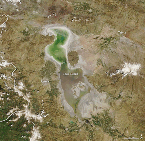
Reviving the Shriveled Lake Urmia
Once the second-largest saltwater lake in the Middle East, Lake Urmia attracted birds and bathers to bask in its turquoise waters in northwest Iran. Then beginning in the 1970s, nearly three decades of drought and high water demands on the lake shriveled the basin, shrinking it by 80 percent. Recent torrential rains have replenished the water levels of this aquatic gem once known as “the turquoise solitaire of Azerbaijan.”
The animation above shows Lake Urmia on April 9, 2018, and April 12, 2019. The images were acquired by the Moderate Resolution Imaging Spectroradiometer (MODIS) on our Terra satellite. Officials report that the lake’s surface area reached roughly 3,000 square kilometers (1,200 square miles) in April 2019—expanding its volume nearly two-fold from a year ago.
Read more about Lake Urmia here.
Make sure to follow us on Tumblr for your regular dose of space: http://nasa.tumblr.com.
Extraordinary Materials: Developed for Space, Useful for Just About Everything on Earth
Did you know technologies developed for space show up all over Earth? Our Technology Transfer Program has one major goal: bring our technology down to Earth. We patent space innovations developed for missions so that companies, startups and entrepreneurs can spin them off into new commercial products.
Our engineers and scientists create all sorts of materials and coatings—in fact, it is one of the most licensed technology categories in our patent portfolio. From materials that improve industrial and household products, to coatings and insulations that protect satellites, machinery and firefighters, our technologies offer smart solutions for modern challenges.
These are a few of our most in-demand technologies.
Dust-Resistant Coatings
Made by innovators at our Langley Research Center, this tech was first created for exploring dusty, dirty surfaces like the Moon, Mars and asteroids. Lunar dust has been shown to cause big problems with mechanical equipment, like clogging filters and damaging seals. This technology can be used in the production of films, coatings and surface treatments to create dust-resistant and self-cleaning products for biomedical devices, aircraft, cars and much more. This tech could be a game-changer when battling dirt and grime.

Smart, Environmentally-Friendly Coating System
Looking for a technology to ward off corrosion that’s also safe for the environment? Developed to protect our launch pads at Kennedy Space Center from extreme heat and exhaust from rockets, this “smart” coating can detect and prevent corrosion. It can even be painted on damaged surfaces to heal and protect them going forward. This tech has commercial potential in building safer bridges, automobiles and machinery. While it may seem like magic, this technology will reduce maintenance cost and improve safety.

Multilayer Fire Protection System
Made to protect astronauts and vehicles during the dangerously hot task of reentry, scientists at Langley developed a flexible, lightweight and portable thermal protection system that can serve as a personal emergency fire shelter.
The flexible technology is made up of multilayer thermal blankets designed to handle external temperatures of up to 2,000°F – that’s as hot as magma found in some volcanos! The system can be formed as a sleeping bag, a tent, a blanket, a curtain, a flexible roll-up doorway or even for fire protection in housing structures.

Super-Strength Aluminums
This award-winning tech was initially developed by researchers at our Marshall Space Flight Center to help reduce vehicle exhaust emissions. This special alloy is flexible and strong—even at temperatures of over 500°F. That means it can withstand more wear and tear than other similar materials. Currently, this tech can be found improving motors on fishing boats as well as in all kinds of different engines.

Oil-Free Lubricants
Not all lubricants are liquids, for example, the non-stick coating on a frying pan. Truly in a class of its own, innovators at our Glenn Research Center have created solid lubricant materials to reduce friction and wear in mechanical parts, especially in extremely high heat. This tech could be useful in large engines, valves, turbines and power generation.

High-Strength Super Elastic Compounds
We needed a better material than iron or steel to prevent corrosion and rust in the International Space Station’s wastewater treatment system. Enter: our high-strength, super elastic compounds. Shock-proof, lightweight, durable and immune to rust, this durable tech has applications in ships, machines, industrial knives and cutters, and engine bearings here on Earth. They also don’t chemically degrade or break down lubricants, a common problem with existing bearing materials.

Interested in licensing the tech mentioned above? Follow the links to apply through our website, http://technology.nasa.gov.
You can also browse our entire materials and coatings portfolio at http://technology.nasa.gov/materials_and_coatings/.
Follow our NASA Technology Transfer Program on Twitter (@NASAsolutions) for the latest updates on technologies available for licensing.
Make sure to follow us on Tumblr for your regular dose of space: http://nasa.tumblr.com.
A Tour of Storms Across the Solar System

Earth is a dynamic and stormy planet with everything from brief, rumbling thunderstorms to enormous, raging hurricanes, which are some of the most powerful and destructive storms on our world. But other planets also have storm clouds, lightning — even rain, of sorts. Let’s take a tour of some of the unusual storms in our solar system and beyond.
Tune in May 22 at 3 p.m. for more solar system forecasting with NASA Chief Scientist Jim Green during the latest installment of NASA Science Live: https://www.nasa.gov/nasasciencelive.

1. At Mercury: A Chance of Morning Micrometeoroid Showers and Magnetic ‘Tornadoes’
Mercury, the planet nearest the Sun, is scorching hot, with daytime temperatures of more than 800 degrees Fahrenheit (about 450 degrees Celsius). It also has weak gravity — only about 38% of Earth's — making it hard for Mercury to hold on to an atmosphere.
Its barely there atmosphere means Mercury doesn’t have dramatic storms, but it does have a strange "weather" pattern of sorts: it’s blasted with micrometeoroids, or tiny dust particles, usually in the morning. It also has magnetic “tornadoes” — twisted bundles of magnetic fields that connect the planet’s magnetic field to space.

2. At Venus: Earth’s ‘Almost’ Twin is a Hot Mess
Venus is often called Earth's twin because the two planets are similar in size and structure. But Venus is the hottest planet in our solar system, roasting at more than 800 degrees Fahrenheit (430 degrees Celsius) under a suffocating blanket of sulfuric acid clouds and a crushing atmosphere. Add to that the fact that Venus has lightning, maybe even more than Earth.
In visible light, Venus appears bright yellowish-white because of its clouds. Earlier this year, Japanese researchers found a giant streak-like structure in the clouds based on observations by the Akatsuki spacecraft orbiting Venus.

3. At Earth: Multiple Storm Hazards Likely
Earth has lots of storms, including thunderstorms, blizzards and tornadoes. Tornadoes can pack winds over 300 miles per hour (480 kilometers per hour) and can cause intense localized damage.
But no storms match hurricanes in size and scale of devastation. Hurricanes, also called typhoons or cyclones, can last for days and have strong winds extending outward for 675 miles (1,100 kilometers). They can annihilate coastal areas and cause damage far inland.

4. At Mars: Hazy with a Chance of Dust Storms
Mars is infamous for intense dust storms, including some that grow to encircle the planet. In 2018, a global dust storm blanketed NASA's record-setting Opportunity rover, ending the mission after 15 years on the surface.
Mars has a thin atmosphere of mostly carbon dioxide. To the human eye, the sky would appear hazy and reddish or butterscotch colored because of all the dust suspended in the air.

5. At Jupiter: A Shrinking Icon
It’s one of the best-known storms in the solar system: Jupiter’s Great Red Spot. It’s raged for at least 300 years and was once big enough to swallow Earth with room to spare. But it’s been shrinking for a century and a half. Nobody knows for sure, but it's possible the Great Red Spot could eventually disappear.

6. At Saturn: A Storm Chasers Paradise
Saturn has one of the most extraordinary atmospheric features in the solar system: a hexagon-shaped cloud pattern at its north pole. The hexagon is a six-sided jet stream with 200-mile-per-hour winds (about 322 kilometers per hour). Each side is a bit wider than Earth and multiple Earths could fit inside. In the middle of the hexagon is what looks like a cosmic belly button, but it’s actually a huge vortex that looks like a hurricane.
Storm chasers would have a field day on Saturn. Part of the southern hemisphere was dubbed "Storm Alley" by scientists on NASA's Cassini mission because of the frequent storm activity the spacecraft observed there.

7. At Titan: Methane Rain and Dust Storms
Earth isn’t the only world in our solar system with bodies of liquid on its surface. Saturn’s moon Titan has rivers, lakes and large seas. It’s the only other world with a cycle of liquids like Earth’s water cycle, with rain falling from clouds, flowing across the surface, filling lakes and seas and evaporating back into the sky. But on Titan, the rain, rivers and seas are made of methane instead of water.
Data from the Cassini spacecraft also revealed what appear to be giant dust storms in Titan’s equatorial regions, making Titan the third solar system body, in addition to Earth and Mars, where dust storms have been observed.

8. At Uranus: A Polar Storm
Scientists were trying to solve a puzzle about clouds on the ice giant planet: What were they made of? When Voyager 2 flew by in 1986, it spotted few clouds. (This was due in part to the thick haze that envelops the planet, as well as Voyager's cameras not being designed to peer through the haze in infrared light.) But in 2018, NASA’s Hubble Space Telescope snapped an image showing a vast, bright, stormy cloud cap across the north pole of Uranus.

9. At Neptune: Methane Clouds
Neptune is our solar system's windiest world. Winds whip clouds of frozen methane across the ice giant planet at speeds of more than 1,200 miles per hour (2,000 kilometers per hour) — about nine times faster than winds on Earth.
Neptune also has huge storm systems. In 1989, NASA’s Voyager 2 spotted two giant storms on Neptune as the spacecraft zipped by the planet. Scientists named the storms “The Great Dark Spot” and “Dark Spot 2.”

10. It’s Not Just Us: Extreme Weather in Another Solar System
Scientists using NASA’s Hubble Space Telescope made a global map of the glow from a turbulent planet outside our solar system. The observations show the exoplanet, called WASP-43b, is a world of extremes. It has winds that howl at the speed of sound, from a 3,000-degree-Fahrenheit (1,600-degree-Celsius) day side, to a pitch-black night side where temperatures plunge below 1,000 degrees Fahrenheit (500 degrees Celsius).
Discovered in 2011, WASP-43b is located 260 light-years away. The planet is too distant to be photographed, but astronomers detected it by observing dips in the light of its parent star as the planet passes in front of it.
Make sure to follow us on Tumblr for your regular dose of space: http://nasa.tumblr.com.

Go green — in space!
Good things come in mini-fridge-sized packages. This small spacecraft is our Green Propellant Infusion Mission and will test a low toxicity propellant. This technology could lengthen mission durations by using less propellant.
Make sure to follow us on Tumblr for your regular dose of space: http://nasa.tumblr.com.
Greenland Refrozen
It won’t be until summertime that a significant amount of melt shows up across the Greenland Ice Sheet. For now, most indications of meltwater ponds and lakes are leftovers from past seasons that have since refrozen.

These photographs were snapped during research flights for NASA’s Operation IceBridge—now in its final year after a decade of airborne missions to map polar ice.

This second image was acquired on April 18, 2019, with the Continuous Airborne Mapping by Optical Translator (CAMBOT) system. The system takes downward-looking images throughout a flight, which can later be used by scientists to interpret other data. This image shows part of a large, frozen lake on Storstrømmen Glacier. This lake also thaws in summertime, which is why it shows up as blue ice.
Lakes atop a glacier, or “supraglacial lakes,” are somewhat stable in terms of their location, according to Joe MacGregor, NASA project scientist for Operation IceBridge. The lake on Storstrømmen is visible in satellite data at least as far back as May 2012. On occasion, water in lakes like this can drain away through a vertical shaft known as a “moulin.” Scientists initially wondered if the dark circular area on the right side of this image could be a moulin, but closer inspection suggested it is just a deeper part of the lake.
See more photos of the frozen lakes in Greenland: https://earthobservatory.nasa.gov/images/144965/greenland-refrozen
Make sure to follow us on Tumblr for your regular dose of space: http://nasa.tumblr.com.
The International Space Station: Apex of International Collaboration
It's National Space Day! To mark the occasion, we're reflecting on the International Space Station, which has been continuously occupied since Nov. 2, 2000. As our orbiting laboratory that enables us to conduct important science off our home planet, the ISS allows researchers from all over the world to put their talents to work on innovative experiments in the microgravity environment. An international partnership of space agencies provides and operates the elements of the ISS. The principals are the space agencies of the United States, Russia, Europe, Japan and Canada. Although each space station partner has distinct agency goals for station research, each partner shares a unified goal to extend the resulting knowledge for the betterment of humanity! Here are 5 fun facts about our about our out-of-this world floating laboratory:
1. The ISS is a unique scientific platform that has enabled more than 3,600 researchers in 106 countries and areas to conduct more than 2,500 experiments in microgravity through February 2018—and the research continues.
2. Astronauts and cosmonauts have conducted more than 205 spacewalks (and counting!) for space station construction, maintenance and repair since December 1998.

3. The station’s orbital path takes it over 90 percent of the Earth’s population, with astronauts taking millions of images of the planet below.
4. Six spaceships can be connected to the space station at once.

5. An international crew of at most six people live and work while traveling at a speed of five miles per second, orbiting Earth about every 90 minutes.
Currently, six humans are living and working on the International Space Station, which orbits 250 miles above our planet at 17,500mph.
Make sure to follow us on Tumblr for your regular dose of space: http://nasa.tumblr.com.
High-Flying Spacecraft Finish 1000th Lap Around Earth!
The quadruplet spacecraft of the Magnetospheric Multiscale mission have just returned from their first adventure into the solar wind — sailing through the most intense winds of their journey so far.

These spacecraft were designed to study Earth’s giant magnetic system, which shields our planet from the majority of the Sun’s constant outflow of material — what we call the solar wind.

Usually, the Magnetospheric Multiscale spacecraft — MMS for short — take their measurements from inside Earth’s protective magnetic environment, the magnetosphere. But in February and March, the MMS spacecraft ventured beyond this magnetic barrier to measure that solar wind directly — a feat that meant they had to change up how they fly in a whole new way.

Outside of Earth's protective magnetic field, the spacecraft were completely immersed in the particles and magnetic fields of the solar wind. As they flew through the stream of material, the spacecraft traced out a wake behind each instrument, just like a boat in a river. To avoid measuring that wake, each spacecraft was tilted into the wind so the instruments could take clean measurements of the pristine solar wind, unaffected by the wake.

Within the magnetosphere, the MMS spacecraft fly in a pyramid-shaped formation that allows them to study magnetic fields in 3D. But to study the solar wind, the mission team aligned spacecraft in a straight line at oddly spaced intervals. This string-of-pearls formation gave MMS a better look at how much the solar wind varies over different scales.

Because the four spacecraft fly so close together, MMS relies on super-accurate navigation from GPS satellites. This venture into the solar wind took the spacecraft even farther from Earth than before, so MMS broke its own world record for highest-ever GPS fix. The spacecraft were over 116,000 miles above Earth — about halfway to the Moon — and still using GPS!

Now, just in time for the 1,000th orbit of their mission — which adds up to 163 million miles flown! — the spacecraft are back in Earth's magnetosphere, flying in their usual formation to study fundamental processes within our planet’s magnetic field.
Keep up with the latest MMS research at nasa.gov/mms, on Twitter @NASASun or with NASA Sun Science on Facebook.
Make sure to follow us on Tumblr for your regular dose of space: http://nasa.tumblr.com
Earth: Our Oasis in Space

Earth: It’s our oasis in space, the one place we know that harbors life. That makes it a weird place -- so far, we haven’t found life anywhere else in the solar system...or beyond. We study our home planet and its delicate balance of water, atmosphere and comfortable temperatures from space, the air, the ocean and the ground.

To celebrate our home, we want to see what you love about our planet. Share a picture, or several, of Earth with #PictureEarth on social media. In return, we’ll share some of our best views of our home, like this one taken from a million miles away by the Earth Polychromatic Imaging Camera (yes, it’s EPIC).

From a DC-8 research plane flying just 1500 feet above Antarctic sea ice, we saw a massive iceberg newly calved off Pine Island Glacier. This is one in a series of large icebergs Pine Island has lost in the last few years – the glacier is one of the fastest melting in Antarctica.

It’s not just planes. We also saw the giant iceberg, known as B-46, from space. Landsat 8 tracked B-46’s progress after it broke off from Pine Island Glacier and began the journey northward, where it began to break apart and melt into the ocean.

Speaking of change, we’ve been launching Earth-observing satellites since 1958. In that time, we’ve seen some major changes. Cutting through soft, sandy soil on its journey to the Bay of Bengal, the Padma River in Bangladesh dances across the landscape in this time-lapse of 30 years’ worth of Landsat images.

Our space-based view of Earth helps us track other natural activities, too. With both a daytime and nighttime view, the Aqua satellite and the Suomi NPP satellite helped us see where wildfires were burning in California, while also tracking burn scars and smoke plumes..

Astronauts have an out-of-this-world view of Earth, literally. A camera mounted on the International Space Station captured this image of Hurricane Florence after it intensified to Category 4.

It’s not just missions studying Earth that capture views of our home planet. Parker Solar Probe turned back and looked at our home planet while en route to the Sun. Earth is the bright, round object.
Want to learn more about our home planet? Check out our third episode of NASA Science Live where we talked about Earth and what makes it so weird.
Make sure to follow us on Tumblr for your regular dose of space: http://nasa.tumblr.com
Far from Westeros, a Three-Eyed Raven Helps NASA Find Its Way
Perched on the outside of the International Space Station is Raven—a technology-filled module that helps NASA develop a relative navigation capability, which is essentially autopilot for spacecraft. Raven has been testing technologies to enable autonomous rendezvous in space, which means the ability to approach things in space without human involvement, even from the ground.

Developed by the Satellite Servicing Projects Division (SSPD), our three-eyed Raven has visible, infrared, and Lidar sensors and uses those “eyes” to image and track visiting spacecraft as they come and go from the space station. Although Raven is all-seeing, it only sees all in black and white. Color images do not offer an advantage in the case of Raven and Restore-L, which also utilize infrared and Lidar sensors.
The data from Raven’s sensors is sent to its processor, which autonomously sends commands that swivel Raven on its gimbal, or pointing system. When Raven turns using this system, it is able to track a vehicle. While these maneuvers take place, NASA operators evaluate the movements and make adjustments to perfect the relative navigation system technologies.

A few days ago, Raven completed its 21st observation of a spacecraft when it captured images of Northrop Grumman’s Cygnus vehicle delivering science investigations and supplies as part of its 11th commercial resupply services mission, including another SSPD payload called the Robotic External Leak Locator.

And just last month, Raven celebrated its two-year anniversary in space, marking the occasion with an observation of SpaceX’s Crew Dragon during the Demo-1 mission.

What is this—a spacecraft for ants??
While this shot of Dragon isn’t terribly impressive because of where the spacecraft docked on station, Raven has captured some truly great images when given the right viewing conditions.
From SpaceX Dragon resupply mission observations…

…to Cygnus supply vehicles.

Raven has observed six unique types of spacecraft.
It has also conducted a few observations not involving spacecraft, including the time it captured Hurricane Irma…

…or the time it captured station’s Dextre arm removing the Robotic Refueling Mission 3 payload, another mission developed by SSPD, from the Dragon spacecraft that delivered it to the orbiting laboratory.


Thus far, Raven has had a great, productive life aboard the station, but its work isn’t done yet! Whether it’s for Restore-L, which will robotically refuel a satellite, or getting humans to the Moon or Mars, the technologies Raven is demonstrating for a relative navigation system will support future NASA missions for decades to come.

Make sure to follow us on Tumblr for your regular dose of space: http://nasa.tumblr.com

A Surprising Surge at Vavilov Ice Cap
After moving quite slowly for decades, the outlet glacier of Vavilov Ice Cap began sliding dozens of times faster than is typical. The ice moved fast enough for the fan-shaped edge of the glacier to protrude from an ice cap on October Revolution Island and spread widely across the Kara Sea. The Landsat images above were acquired on July 1, 2013, June 18, 2015, and June 24, 2018, respectively.
“The fact that an apparently stable, cold-based glacier suddenly went from moving 20 meters per year to 20 meters per day was extremely unusual, perhaps unprecedented,” said University of Colorado Boulder glaciologist Michael Willis. “The numbers here are simply nuts. Before this happened, as far as I knew, cold-based glaciers simply didn’t do that...couldn’t do that.”
Willis and his colleagues are still piecing together what triggered such a dramatic surge. They suspect that marine sediments immediately offshore are unusually slippery, perhaps containing clay. Also, water must have somehow found its way under the land-based part of the glacier, reducing friction and priming the ice to slide.
Full story here: go.nasa.gov/2Z931lc
Make sure to follow us on Tumblr for your regular dose of space: http://nasa.tumblr.com
How NASA Earth Data Aids America

Today we roll out a new communications project that highlights some of the many ways that NASA's Earth observations help people strengthen communities across the United States.
Space for U.S. features stories on how Earth science data is used to make informed decisions about public health, disaster response and recovery and environmental protection. By highlighting advanced technology from a global perspective, our data helps provide people achieve groundbreaking insights.

For example, a family-owned coffee company in Maine used our sunlight, wind and temperature data to determine the placement of their power-generating solar wall.
Space for U.S. features 56 stories illustrating how our science has made an impact in every state in the nation as well as the District of Columbia, Puerto Rico and regions along the Atlantic, Pacific, Gulf of Mexico, and the Great Lakes.

For six decades, we've used the vantage point of space to better understand our home planet and improve lives. Using Space for U.S., you can browse through stories about how applied Earth science either by state or by topics such as animals, disasters, energy, health, land and water. Each click brings you a story about how people are putting NASA data to work.

Explore the true stories behind the innovative technology, groundbreaking insights, and extraordinary collaboration happening right here in the United States with Space for U.S.
Check out "Space for U.S." today! www.nasa.gov/spaceforus

For more information on NASA Earth, head to www.nasa.gov/Earth or https://appliedsciences.nasa.gov.
Make sure to follow us on Tumblr for your regular dose of space: http://nasa.tumblr.com.

This is no Westeros. On April 8, 2019, the Landsat 8 satellite acquired a scene of contrasts in Russia: a fire surrounded by ice.
Between chunks of frozen land and lakes in the Magadan Oblast district of Siberia, a fire burned and billowed smoke plumes that were visible from space.
Not much is known about the cause of the fire, east of the town of Evensk. Forest fires are common in this heavily forested region, and the season usually starts in April or May. Farmers also burn old crops to clear fields and replenish the soil with nutrients, also known as ‘slash and burn agriculture’; such fires occasionally burn out of control. Land cover maps, however, show that this fire region is mainly comprised of shrublands, not croplands.
Make sure to follow us on Tumblr for your regular dose of space: http://nasa.tumblr.com
The International Space Station Through the Eyes of Little Earth!
Currently, six humans are living and working on the International Space Station, which orbits 250 miles above our planet at 17,500mph. Accompanying their mission is a zero-g indicator, informally known as “Little Earth”.
Greetings fellow Earthlings! Curious about my first week on the International Space Station? What does a normal day look like when you’re living and working hundreds of miles above Earth? Take a look at some photos from my first week, when I was still learning the ropes from my new roommates!
Welcome Ceremony
Talk about a warm welcome! I arrived on March 3, 2019 when the SpaceX Crew Dragon docked to the Space Station for the first time. This historic mission marked the first time a commercially built American spacecraft intended for human spaceflight docked to the orbital lab. Though un-crewed, Dragon was carrying two very important passengers – my space travel companion Ripley and myself, Astronaut Little Earth. During my three-day introduction to the station, two Expedition 59 astronauts, Anne McClain and David Saint-Jacques, taught me what it takes to be a Space Station crew member!
Earth Watching

First thing’s first – the VIEW. After the traditional hatch opening welcome ceremony, I was off to the Cupola Observational Module. Designed for the observation of operations outside the station, this module’s six side windows also provide spectacular views of our Mother Earth! My roommate Anne McClain introduced me to the beautiful vantage point of space. Clearly, I was a little star-struck.
Space Suit Sizing

Next, it was time to get to work – lending a hand with Anne McClain’s space suit sizing. Did you know you actually grow in zero gravity? Astronaut McClain has grown two inches on her current mission in space. Crew members must account for this change in growth to know if different components need to be switched out of their individual spacesuit for a better fit. When pressurized and filled with oxygen, the spacesuits become stiff objects around the astronauts inside, making it critical they fit comfortably. These spacesuits are essentially mini spacecraft that provide protection and a means of survival for the astronauts as they venture outside the space station and into the harsh environment of space.
Space Coffee!

One Café Latte, please! I was thrilled to find out that even in space, the morning begins with a pick me up. Due to microgravity, liquids tend to get sticky and cling to the wall of cups, making these plastic pouches and straws necessary for consumption. Astronauts in 2015 got an upgrade to their morning cup of joe thanks to SpaceX, Lavazza and the Italian Space Agency. Named the ISSpresso, a microgravity coffee maker has brought authentic Italian espresso with zero-G coffee cups onto the International Space Station.
Emergency Mask Donning

Fueled up and ready for the day, my next agenda item was emergency preparedness practice. There is no 9-1-1 in space, and three events that could pose a dangerous threat to the Space Station include a fire, a depressurization event or an ammonia breakout. Here, Canadian Astronaut David Saint-Jacques and I practiced emergency mask donning in the unlikely event of an ammonia leak into the station’s atmosphere.
Preventative Maintenance

From astronaut to astro-plumber, I traded my mask for goggles with Astronaut Anne McClain during a briefing on plumbing routine maintenance. Because the International Space Station never returns to Earth, the crew is trained to regularly inspect, replace and clean parts inside the station.
Daily Exercise

Talk about staying healthy! After a busy day, Astronaut McClain and I continued to hit the ground running, literally. Crew members are required to work out daily for about two hours to help keep their heart, bones and muscles strong in zero gravity. The harness McClain is wearing is very much like a backpacking harness, designed to evenly distribute weight across her upper body and is attached to a system of bungees and cords. Depending on the tension in these attachments, a specific load of pressure is applied to her body onto the machine.
Strength Training in Zero-G

Watch out, deadlift going on. Running isn’t the only gym exercise they have onboard; strength training is also incorporated into the daily exercise regime.
Robotics Operations: Canadarm2

You can look, just don’t touch they told me. Whoops. This was a definite highlight, my Canadarm 2 briefing. That black nob by my hand is the translational hand controller. It operates the up and down function of the 57.7-foot-long robotic arm. The Canadarm2 lends a literal helping hand with many station functions, using a “hand” known as a Latching End Effector to perform tasks such as in orbit maintenance, moving supplies and performing “cosmic catches”.
Crew Group Dinner

Whew, you work up a big appetite working on the Space Station. Ending the day, I was introduced to a crew favorite, group dinner! Astronauts and cosmonauts from around the world come together on the orbital lab and bring with them a variety of cultures and ... food! Though each country is responsible for feeding its own members, when on board the astronauts can share as they please. A new friend of mine, Paxi from the European Space Agency, welcomed my visit and we split a delicious space-shrimp cocktail.
And that’s a wrap to a busy first week aboard the International Space Station! Learn more about what it means to live and work aboard the International Space Station, and click here to see if you have what it takes to become a NASA Astronaut. Until next time!
Make sure to follow us on Tumblr for your regular dose of space: http://nasa.tumblr.com
Be Glad You Don’t Have to Dust in Space!
Throw open the windows and break out the feather duster, because spring is here and it’s time to do a little cleaning! Fortunately, no one has to tidy up the dust in space — because there’s a lot of it — around 100 tons rain down on Earth alone every day! And there’s even more swirling around the solar system, our Milky Way galaxy, other galaxies and the spaces in between.

By studying the contents of the dust in your house — which can include skin cells, pet fur, furniture fibers, pollen, concrete particles and more — scientists learn a lot about your environment. In the same way, scientists can learn a lot by looking at space dust. Also called cosmic dust, a fleck of space dust is usually smaller than a grain of sand and is made of rock, ice, minerals or organic compounds. Scientists can study cosmic dust to learn about how it formed and how the universe recycles material.

“We are made of star-stuff,” Carl Sagan famously said. And it’s true! When a star dies, it sheds clouds of gas in strong stellar winds or in an explosion called a supernova. As the gas cools, minerals condense. Recent observations by our SOFIA mission suggest that in the wake of a supernova shockwave, dust may form more rapidly than scientists previously thought. These clouds of gas and dust created by the deaths of stars can sprawl across light-years and form new stars — like the Horsehead Nebula pictured above. Disks of dust and gas form around new stars and produce planets, moons, asteroids and comets. Here on Earth, some of that space dust eventually became included in living organisms — like us! Billions of years from now, our Sun will die too. The gas and dust it sheds will be recycled into new stars and planets and so on and so forth, in perpetuity!

Astronomers originally thought dust was a nuisance that got in the way of seeing the objects it surrounded. Dust scatters and absorbs light from stars and emits heat as infrared light. Once we started using infrared telescopes, we began to understand just how important dust is in the universe and how beautiful it can be. The picture of the Andromeda galaxy above was taken in the infrared by our Spitzer Space Telescope and reveals detailed spirals of dust that we can’t see in an optical image.

We also see plenty of dust right here in our solar system. Saturn’s rings are made of mostly ice particles and some dust, but scientists think that dust from meteorites may be darkening the rings over time. Jupiter also has faint dusty rings, although they’re hard to see — Voyager 1 only discovered them when it saw them backlit by the Sun. Astronomers think the rings formed when meteorite impacts on Jupiter’s moons released dust into orbit. The Juno spacecraft took the above picture in 2016 from inside the rings, looking out at the bright star Betelgeuse.

Copyright Josh Calcino, used with permission
And some space dust you can see from right here on Earth! In spring or autumn, right before sunrise or after sunset, you may be able to catch a glimpse of a hazy cone of light above the horizon created when the Sun’s rays are scattered by dust in the inner solar system. You can see an example in the image above, extending from above the tree on the horizon toward a spectacular view of the Milky Way. This phenomenon is called zodiacal light — and the dust that’s reflecting the sunlight probably comes from icy comets. Those comets were created by the same dusty disk that that formed our planets and eventually you and the dust under your couch!
Make sure to follow us on Tumblr for your regular dose of space: http://nasa.tumblr.com
Our Planet: 8 Stunning Views of Earth from Space
Swirling clouds, deep blue oceans and textured land- and icescapes are among the many faces of our planet revealed in NASA’s new photo-essay book: Earth. This collection of 69 images captured by satellites tells a story of a 4.5-billion-year-old planet where there is always something new to see. Earth is a beautiful, awe-inspiring place, and it is the only world most of us will ever know. It is your planet. It is NASA’s mission. The book is available now in hardcover and ebook, and online with interactive features.
Here are eight of those breathtaking images for your viewing pleasure.
Channel Country, Australia

These wide floodplains in Queensland, Australia are unique on the planet. Scientists think they are caused by the extreme variation in water and sediment discharges from the rivers. In many years there is no rainfall at all, and the rivers are effectively non-existent. In years of modest rainfall, the main channels will carry some water, sometimes spilling over into narrow water holes known as billabongs.
Every few decades, the floodplain carries extremely high discharges of water. For instance, tropical storms to the north can lead to great water flows that inundate the entire width of the floodplain. On such occasions, the floodplain appears as series of brown and green water surfaces with only tree tops indicating the location of the islands. Such is the case in this image taken from the International Space Station in September 2016.
Grounded in the Caspian, Kazakhstan

A wide variety of ice forms in the Caspian Sea, which stretches from Kazakhstan to Iran. Just offshore, a well-developed expanse of consolidated ice appears bright white. Farther offshore, a gray-white field of chunky, hummocked ice has detached and is slowly drifting around a polynya, an area of open water surrounded by sea ice. That darker patch is actually growing young, thin ice and nilas, a term that designates sea ice crust up to 10 centimeters (4 inches) in thickness.
The close-up shows nilas and a white, diamond-shaped piece of ice. It might look like this chunk is on the move, cutting a path through thinner ice. But it’s more likely that the “diamond” was stuck to the sea bottom and the wind pushed ice around it.
Tsauchab River Bed, Namibia

The Tsauchab River is a famous landmark for the people of Namibia and tourists. Yet few people have ever seen the river flowing with water. In December 2009, an astronaut on the International Space Station caught this glimpse of the Tsauchab River bed jutting into the sea of red dunes. It ends in a series of light-colored, silty mud holes on the dry lake floor.
Like several other rivers around the Namib Desert, the Tsauchab brings sediment down from the hinterland toward the coastal lowland. This sediment is then blown from the river beds, and over tens of millions of years it has accumulated as the red dunes of the Namib Sand Sea.
Taranaki and Egmont, New Zealand

The circular pattern of New Zealand’s Egmont National Park stands out from space as a human fingerprint on the landscape. The park protects the forested and snow-capped slopes around Mount Taranaki (Mount Egmont to British settlers). It was established in 1900, when officials drew a radius of 10 kilometers around the volcanic peak. The colors differentiate the protected forest (dark green) from once-forested pasturelands (light- and brown-green).
Named by the native Maori people, Taranaki stands 2,518 meters (8,260 feet) tall, and it is one of the world’s most symmetric volcanoes. It first became active about 135,000 years ago. By dating lava flows, geologists have figured out that small eruptions occur roughly every 90 years and major eruptions every 500 years. Landsat 8 acquired this image of Taranaki and the park in July 2014.
Storms Stir Up Sediment in Bermuda

In October 2014, the eye of Hurricane Gonzalo passed right over Bermuda. In the process, the potent storm stirred up the sediments in the shallow bays and lagoons around the island, spreading a huge mass of sediment across the North Atlantic Ocean. This Landsat 8 image shows the area after Gonzalo passed through.
The suspended sediments were likely a combination of beach sand and carbonate sediments from around the shallows and reefs. Coral reefs can produce large amounts of calcium carbonate, which stays on the reef flats (where there are coralline algae that also produce carbonate) and builds up over time to form islands.
Framing an Iceberg in the South Atlantic Ocean

In June 2016, the Suomi NPP satellite captured this image of various cloud formations in the South Atlantic Ocean. Note how low stratus clouds framed a hole over iceberg A-56 as it drifted across the sea.
The exact reason for the hole in the clouds is somewhat of a mystery. It could have formed by chance, although imagery from the days before and after this date suggest something else was at work. It could be that the relatively unobstructed path of the clouds over the ocean surface was interrupted by thermal instability created by the iceberg. In other words, if an obstacle is big enough, it can divert the low-level atmospheric flow of air around it, a phenomenon often caused by islands.
Lofted Over Land in Madagascar

Along the muddy Mania River, midday clouds form over the forested land but not the water. In the tropical rainforests of Madagascar, there is ample moisture for cloud formation. Sunlight heats the land all day, warming that moist air and causing it to rise high into the atmosphere until it cools and condenses into water droplets. Clouds generally form where air is ascending (over land in this case), but not where it is descending (over the river). Landsat 8 acquired this image in January 2015.
A Lava Lamp Look at the Atlantic Ocean

Stretching from tropical Florida to the doorstep of Europe, the Gulf Stream carries a lot of heat, salt, and history. This river of water is an important part of the global ocean conveyor belt, moving water and heat from the Equator toward the far North Atlantic. It is one of the strongest currents on Earth and one of the most studied. Its discovery is often attributed to Benjamin Franklin, though sailors likely knew about the current long before they had a name for it.
This image shows a small portion of the Gulf Stream off of South Carolina as it appeared in infrared data collected by the Landsat 8 satellite in April 2013. Colors represent the energy—heat—being emitted by the water, with cooler temperatures in purple and the warmest water being nearly white. Note how the Gulf Stream is not a uniform band but instead has finer streams and pockets of warmer and colder water.
These images are just a few from our new book called Earth. Explore the other 61 images here.
Make sure to follow us on Tumblr for your regular dose of space: http://nasa.tumblr.com
Flooding Along the Mississippi
Rain, snowmelt, and soil moisture—those three factors might push portions of the Upper Mississippi River into major flooding this spring. Meanwhile, the middle and lower reaches of the river are already well out of their banks.
Intense storms over February 22-24, 2019, caused major flooding along the Middle Mississippi River. On February 25, 2019, the Landsat 8 satellite acquired images of swollen portions of the Mississippi River. The video above shows a false-color view of flooding near Memphis, Tennessee comparing February 2019 to February 2014. Flood waters appear blue; vegetation is green; and bare ground is brown. Notice how the Ohio River and Mississippi River have swelled near Cairo, the southernmost city in Illinois.
National Weather Service forecasters noted that higher-than-average precipitation in autumn 2018 saturated soils in the region, so additional rain or snowmelt from this winter will likely result in excessive runoff and increased flooding threats.
Rapid snowmelt will also play a role in flooding this spring in the Midwest. Parts of Minnesota and Wisconsin have built up snowpack of nearly 25 inches, so melting snow alone could propel many areas into major flooding.
Read the full story here.
Make sure to follow us on Tumblr for your regular dose of space: http://nasa.tumblr.com
Five Facts About the Kepler Space Telescope That Will Blow You Away!

Ten years ago, on March 6, 2009, a rocket lifted off a launch pad at Cape Canaveral Air Force Station in Florida. It carried a passenger that would revolutionize our understanding of our place in the cosmos--NASA’s first planet hunter, the Kepler space telescope. The spacecraft spent more than nine years in orbit around the Sun, collecting an unprecedented dataset for science that revealed our galaxy is teeming with planets. It found planets that are in some ways similar to Earth, raising the prospects for life elsewhere in the cosmos, and stunned the world with many other first-of-a-kind discoveries. Here are five facts about the Kepler space telescope that will blow you away:
Kepler observed more than a half million stars looking for planets beyond our solar system.

It discovered more than 2,600 new worlds…

…many of which could be promising places for life.

Kepler’s survey revealed there are more planets than stars in our galaxy.

The spacecraft is now drifting around the Sun more than 94 million miles away from Earth in a safe orbit.

NASA retired the Kepler spacecraft in 2018. But to this day, researchers continue to mine its archive of data, uncovering new worlds.
*All images are artist illustrations. Make sure to follow us on Tumblr for your regular dose of space: http://nasa.tumblr.com
Weathering the Storm with our Global Precipitation Measurement Mission
How much rain falls in a hurricane? How much snow falls in a nor’easter? What even is a nor’easter? These are the sorts of questions answered by our Global Precipitation Measurement Mission, or GPM.
GPM measures precipitation: Rain, snow, sleet, freezing rain, hail, ice pellets. It tells meteorologists the volume, intensity and location of the precipitation that falls in weather systems, helping them improve their forecasting, gather information about extreme weather and better understand Earth’s energy and water cycles.
And putting all that together, one of GPM’s specialties is measuring storms.
GPM is marking its fifth birthday this year, and to celebrate, we’re looking back on some severe storms that the mission measured in its first five years.
1. The Nor’easter of 2018

A nor’easter is a swirling storm with strong northeasterly winds and often lots of snow. In January 2018, the mission’s main satellite, the Core Observatory, flew over the East Coast in time to capture the development of a nor’easter. The storm dumped 18 inches of snow in parts of New England and unleashed winds up to 80 miles per hour!
2. Hurricane Harvey

Hurricane Harvey came to a virtual halt over eastern Texas in August 2017, producing the largest rain event in U.S. history. Harvey dropped up to 5 feet of rain, causing $125 billion in damage. The Core Observatory passed over the storm several times, using its radar and microwave instruments to capture the devastating deluge.
3. Typhoon Vongfong
In October 2014, GPM flew over one of its very first Category 5 typhoons – tropical storms with wind speeds faster than 157 miles per hour. The storm was Typhoon Vongfong, which caused $48 million in damage in Japan, the Philippines and Taiwan. We were able to see both the pattern and the intensity of Vongfong’s rain, which let meteorologists know the storm’s structure and how it might behave.
4. Near Real-Time Global Precipitation Calculations
The Core Observatory isn’t GPM’s only satellite! A dozen other satellites from different countries and government agencies come together to share their microwave measurements with the Core Observatory. Together, they are called the GPM Constellation, and they create one of its most impressive products, IMERG.
IMERG stands for “Integrated Multi-satellitE Retrievals for GPM,” and it uses the info from all the satellites in the Constellation to calculate global precipitation in near real time. In other words, we can see where it’s raining anywhere in the world, practically live.
5. Hurricane Ophelia
Hurricane Ophelia hit Ireland and the United Kingdom in October 2017, pounding them with winds up to 115 miles per hour, reddening the skies with dust from the Sahara Desert and causing more than $79 million in damages. Several satellites from the Constellation passed over Ophelia, watching this mid-latitude weather system develop into a Category 3 hurricane – the easternmost Category 3 storm in the satellite era (since 1970).
From the softest snow to the fiercest hurricanes, GPM is keeping a weather eye open for precipitation around the world. And we’re on cloud nine about that.
Make sure to follow us on Tumblr for your regular dose of space: http://nasa.tumblr.com
Demo-1: What’s the Deal?
Whether or not you caught the SpaceX Crew Dragon launch this past weekend, here’s your chance to learn why this mission, known as Demo-1, is such a big deal.
The First of its Kind
Demo-1 is the first flight test of an American spacecraft designed for humans built and operated by a commercial company.
Liftoff

The SpaceX Crew Dragon lifted off at 2:49 a.m. EST Saturday, March 2, on the company’s Falcon 9 rocket from Kennedy Space Center.
This was the first time in history a commercially-built American crew spacecraft and rocket launched from American soil.
A New Era in Human Spaceflight

Upon seeing the arriving spacecraft, NASA astronaut Anne McClain snapped a photo from the International Space Station: “Welcome to a new era in human spaceflight.”
Docking the Dragon

After making 18 orbits of Earth, the Crew Dragon spacecraft successfully attached to the International Space Station’s Harmony module at 5:51 a.m. EST Sunday, March 3. The Crew Dragon used the station’s new international docking adapter for the first time since astronauts installed it in August 2016.
The docking phase, in addition to the return and recovery of Crew Dragon, are critical to understanding the system’s ability to support crew flights.
Opening the Hatch

After opening the hatch between the two spacecraft, the crewmates configured Crew Dragon for its stay.
They installed a ventilation system that cycles air from Crew Dragon to the station, installed window covers and checked valves. After that, the crew was all set for a welcoming ceremony for the visiting vehicle.
Ripley and Little Earth

Although the test is uncrewed, that doesn’t mean the Crew Dragon is empty. Along for the ride was Ripley, a lifelike test device outfitted with sensors to provide data about potential effects on future astronauts. (There is also a plush Earth doll included inside that can float in the microgravity!)
Inside the Dragon
For future operational missions, Crew Dragon will be able to launch as many as four crew members and carry more than 220 pounds of cargo. This will increase the number of astronauts who are able to live onboard the station, which will create more time for research in the unique microgravity environment.
Integration

Since the arrival of SpaceX Crew Dragon, the three Expedition 58 crew members have returned to normal operations (with some new additions to the team!)
Undocking

The Crew Dragon is designed to stay docked to station for up to 210 days, although the spacecraft used for this flight test will remain docked to the space station for only five days, departing Friday, March 8. (We will be providing live coverage — don’t miss it!)
SpaceX and NASA

Elon Musk, CEO and lead designer at SpaceX, expressed appreciation for NASA’s support: “SpaceX would not be here without NASA, without the incredible work that was done before SpaceX even started and without the support after SpaceX did start.”
Preparation for Demo-2

NASA and SpaceX will use data from Demo-1 to further prepare for Demo-2, the crewed flight test that will carry NASA astronauts and Doug Hurley and Bob Behnken to the International Space Station. NASA will validate the performance of SpaceX’s systems before putting crew on board for the Demo-2 flight, currently targeted for July 2019.
Demo-1: So What?

Demo-1 is a big deal because it demonstrates NASA and commercial companies working together to advance future space exploration! With Demo-1’s success, NASA and SpaceX will begin to prepare to safely fly astronauts to the orbital laboratory.
Follow along with mission updates with the Space Station blog.
Make sure to follow us on Tumblr for your regular dose of space: http://nasa.tumblr.com
Countdown to Calving at Antarctica's Brunt Ice Shelf

Cracks growing across Antarctica’s Brunt Ice Shelf are poised to release an iceberg with an area about twice the size of New York City, (about 604 square miles). It is not yet clear how the remaining ice shelf will respond following the break, posing an uncertain future for scientific infrastructure and a human presence on the shelf that was first established in 1955.

NASA Earth Observatory image by Joshua Stevens, using Landsat data from the U.S. Geological Survey. Story by Kathryn Hansen, with image interpretation by Chris Shuman (NASA/UMBC).
The above image, from the Operational Land Imager (OLI) on Landsat 8, shows the area on January 23, 2019. The crack along the top of the image—the so-called Halloween crack—first appeared in late October 2016 and continues to grow eastward from an area known as the McDonald Ice Rumples. The rumples are due to the way ice flows over an underwater formation, where the bedrock rises high enough to reach into the underside of the ice shelf. This rocky formation impedes the flow of ice and causes pressure waves, crevasses, and rifts to form at the surface.
The more immediate concern is the rift visible in the center of the image. Previously stable for about 35 years, this crack recently started accelerating northward as fast as 4 kilometers per year.
Calving is a normal part of the life cycle of ice shelves, but the recent changes are unfamiliar in this area. The edge of the Brunt Ice Shelf has evolved slowly since Ernest Shackleton surveyed the coast in 1915, but it has been speeding up in the past several years.
Make sure to follow us on Tumblr for your regular dose of space: http://nasa.tumblr.com
The Pale Blue Dot and the Golden Record
Almost thirty years ago, on Feb. 14, 1990, our Voyager 1 spacecraft turned back toward its home for one last look. 40 astronomical units (almost 4 billion miles) from the Sun, Voyager snapped the first-ever “family portrait” of our solar system.

One image in particular highlights our own planet’s fragility in the vast cosmic arena that we call home. This image of Earth, a tiny point of light, is contained in a camera artifact that resembles a beam of sunlight.

The late Carl Sagan referred to this image of Earth in the title of his 1994 book, Pale Blue Dot. Sagan wrote: "That's here. That's home. That's us. On it everyone you love, everyone you know, everyone you ever heard of, every human being who ever was, lived out their lives. … There is perhaps no better demonstration of the folly of human conceits than this distant image of our tiny world. To me, it underscores our responsibility to deal more kindly with one another, and to preserve and cherish the pale blue dot, the only home we've ever known.”
We placed a message aboard Voyager 1 and 2 — a kind of time capsule intended to communicate a story of our world to extraterrestrials. The Voyager message is carried by a phonograph record: a 12-inch gold-plated copper disk containing sounds and images selected to portray the diversity of life and culture on Earth.

The Golden Record includes 115 images and a variety of natural sounds, such as those made by surf, wind and thunder, birds, whales and other animals. Musical selections from different cultures and eras were also added, as well as spoken greetings from Earth-people in fifty-five languages and printed messages from President Carter.
The Golden Record represents the whole of humanity, mounted to a feat of human engineering on a long voyage through interstellar space.

You can listen to the sounds of Earth on the golden record here and take a moment to appreciate our pale blue dot.
Make sure to follow us on Tumblr for your regular dose of space: http://nasa.tumblr.com
Our Favorite Valentines Throughout the Universe
Today is Valentine’s Day. What better way to express that you love someone than with an intergalactic love gram? Check out some of our favorites and send them to all of your cosmic companions:
Your love is galactic

The Hubble Space Telescope revolutionized nearly all areas of astronomical research — and captured some truly lovely images. Here, a pair of intersecting galaxies swirl into the shape of a rose as a result of gravitational tidal pull. What type of roses are you getting for your love — red or galactic?
I think you’re n{ice}

IceBridge is the largest airborne survey of Earth’s polar ice ever flown. It captures 3-D views of Arctic and Antarctic ice sheets, ice shelves and sea ice. This lovely heart-shaped glacier feature was discovered in northwest Greenland during an IceBridge flight in 2017. Which of your lover’s features would you say are the coolest?
You’re absolutely magnetic

Even though we can't see them, magnetic fields are all around us. One of the solar system’s largest magnetospheres belongs to Jupiter. Right now, our Juno spacecraft is providing scientists with their first glimpses of this unseen force. Is your attraction to your loved one magnetic?
You’re MARS-velous

This heart-shaped feature on the Martian landscape was captured by our Mars Reconnaissance Orbiter. It was created by a small impact crater that blew darker material on the surface away. What impact has your loved one had on you?
I <3 you

From three billion miles away, Pluto sent a “love note” back to Earth, via our New Horizons spacecraft. This stunning image of Pluto's "heart" shows one of the world's most dominant features, estimated to be 1,000 miles (1,600 km) across at its widest point. Will you pass this love note on to someone special in your life?
Light of my life

Our Solar Dynamics Observatory keeps an eye on our closest star that brings energy to you and your love. The observatory helps us understand where the Sun's energy comes from, how the inside of the Sun works, how energy is stored and released in the Sun's atmosphere and much more. Who would you say is your ray of sunshine?
Do any of these cosmic phenomena remind you of someone in your universe? Download these cards here to send to all the stars in your sky.
Want something from the Red Planet to match your bouquet of red roses? Here is our collection of Martian Valentines.
Make sure to follow us on Tumblr for your regular dose of space: http://nasa.tumblr.com
5 Facts About Earth's Radiation Donuts 🍩
Did you know that our planet is surrounded by giant, donut-shaped clouds of radiation?

Here's what you need to know.
1. The radiation belts are a side effect of Earth's magnetic field

The Van Allen radiation belts exist because fast-moving charged particles get trapped inside Earth's natural magnetic field, forming two concentric donut-shaped clouds of radiation. Other planets with global magnetic fields, like Jupiter, also have radiation belts.
2. The radiation belts were one of our first Space Age discoveries

Earth's radiation belts were first identified in 1958 by Explorer 1, the first U.S. satellite. The inner belt, composed predominantly of protons, and the outer belt, mostly electrons, would come to be named the Van Allen Belts, after James Van Allen, the scientist who led the charge designing the instruments and studying the radiation data from Explorer 1.
3. The Van Allen Probes have spent six years exploring the radiation belts

In 2012, we launched the twin Van Allen Probes to study the radiation belts. Over the past six years, these spacecraft have orbited in and out of the belts, providing brand-new data about how the radiation belts shift and change in response to solar activity and other factors.
4. Surprise! Sometimes there are three radiation belts

Shortly after launch, the Van Allen Probes detected a previously-unknown third radiation belt, created by a bout of strong solar activity. All the extra energy directed towards Earth meant that some particles trapped in our planet's magnetic field were swept out into the usually relatively empty region between the two Van Allen Belts, creating an additional radiation belt.
5. Swan song for the Van Allen Probes

Originally designed for a two-year mission, the Van Allen Probes have spent more than six years collecting data in the harsh radiation environment of the Van Allen Belts. In spring 2019, we're changing their orbit to bring the perigee — the part of the orbit where the spacecraft are closest to Earth — about 190 miles lower. This ensures that the spacecraft will eventually burn up in Earth's atmosphere, instead of orbiting forever and becoming space junk.
Because the Van Allen Probes have proven to be so hardy, they'll continue collecting data throughout the final months of the mission until they run out of fuel. As they skim through the outer reaches of Earth's atmosphere, scientists and engineers will also learn more about how atmospheric oxygen can degrade satellite measurements — information that can help build better satellites in the future.
Keep up with the latest on the mission on Twitter, Facebook or nasa.gov/vanallenprobes.
Greatest Hits — Craters We Love
Our solar system was built on impacts — some big, some small — some fast, some slow. This week, in honor of a possible newly-discovered large crater here on Earth, here’s a quick run through of some of the more intriguing impacts across our solar system.
1. Mercury: A Basin Bigger Than Texas

Mercury does not have a thick atmosphere to protect it from space debris. The small planet is riddled with craters, but none as spectacular as the Caloris Basin. “Basin” is what geologists call craters larger than about 186 miles (300 kilometers) in diameter. Caloris is about 950 miles (1,525 kilometers) across and is ringed by mile-high mountains.
For scale, the state of Texas is 773 miles (1,244 kilometers) wide from east to west.
2. Venus: Tough on Space Rocks

Venus’ ultra-thick atmosphere finishes off most meteors before they reach the surface. The planet’s volcanic history has erased many of its craters, but like almost any place with solid ground in our solar system, there are still impact scars to be found. Most of what we know of Venus’ craters comes from radar images provided by orbiting spacecraft, such as NASA’s Magellan.
Mead Crater is the largest known impact site on Venus. It is about 170 miles (275 kilometers) in diameter. The relatively-flat, brighter inner floor of the crater indicates it was filled with impact melt and/or lava.
3. Earth: Still Craters After All These Years

Evidence of really big impacts — such as Arizona’s Meteor Crater — are harder to find on Earth. The impact history of our home world has largely been erased by weather and water or buried under lava, rock or ice. Nonetheless, we still find new giant craters occasionally.
A NASA glaciologist has discovered a possible impact crater buried under more than a mile of ice in northwest Greenland.
This follows the finding, announced in November 2018, of a 19-mile (31-kilometer) wide crater beneath Hiawatha Glacier – the first meteorite impact crater ever discovered under Earth’s ice sheets.
If the second crater, which has a width of over 22 miles (35 kilometers), is ultimately confirmed as the result of a meteorite impact, it will be the 22nd largest impact crater found on Earth.
4. Moon: Our Cratered Companion

Want to imagine what Earth might look like without its protective atmosphere, weather, water and other crater-erasing features? Look up at the Moon. The Moon’s pockmarked face offers what may be humanity’s most familiar view of impact craters.
One of the easiest to spot is Tycho, the tight circle and bright, radiating splat are easy slightly off center on the lower-left side of the full moon. Closer views of the 53-mile (85 kilometer)-wide crater from orbiting spacecraft reveal a beautiful central peak, topped with an intriguing boulder that would fill about half of a typical city block.
5. Mars: Still Taking Hits

Mars has just enough atmosphere to ensure nail-biting spacecraft landings, but not enough to prevent regular hits from falling space rocks. This dark splat on the Martian south pole is less than a year old, having formed between July and September 2018. The two-toned blast pattern tells a geologic story. The larger, lighter-colored blast pattern could be the result of scouring by winds from the impact shockwave on ice. The darker-colored inner blast pattern is because the impactor penetrated the thin ice layer, blasting the dark sand underneath in all directions.
6. Ceres: What Lies Beneath

The bright spots in Ceres’ Occator crater intrigued the world from the moment the approaching Dawn spacecraft first photographed it in 2015. Closer inspection from orbit revealed the spots to be the most visible example of hundreds of bright, salty deposits that decorate the dwarf planet like a smattering of diamonds. The science behind these bright spots is even more compelling: they are mainly sodium carbonate and ammonium chloride that somehow made their way to the surface in a slushy brine from within or below the crust. Thanks to Dawn, scientists have a better sense of how these reflective areas formed and changed over time — processes indicative of an active, evolving world.
7. Comet Tempel 1: We Did It!

Scientists have long known we can learn a lot from impact craters — so, in 2005, they made one themselves and watched it happen.
On July 4, 2005, NASA’s Deep Impact spacecraft trained its instruments on an 816-pound (370-kilogram) copper impactor as it smashed into comet Tempel 1.
One of the more surprising findings: The comet has a loose, “fluffy” structure, held together by gravity and contains a surprising amount of organic compounds that are part of the basic building blocks of life.
8. Mimas: May the 4th Be With You

Few Star Wars fans — us included — can resist Obi Wan Kenobi's memorable line “That’s no moon…” when images of Saturn’s moon Mimas pop up on a screen. Despite its Death Star-like appearance, Mimas is most definitely a moon. Our Cassini spacecraft checked, a lot — and the superlaser-looking depression is simply an 81-mile (130-kilometer) wide crater named for the moon’s discoverer, William Herschel.
9. Europa: Say What?

The Welsh name of this crater on Jupiter’s ocean moon Europa looks like a tongue-twister, but it is easiest pronounced as “pool.” Pwyll is thought to be one of the youngest features we know of on Europa. The bright splat from the impact extends more than 600 miles (about 1,000 kilometers) around the crater, a fresh blanket over rugged, older terrain. “Fresh,” or young, is a relative term in geology; the crater and its rays are likely millions of years old.
10. Show Us Your Greatest Hits

Got a passion for Stickney, the dominant bowl-shaped crater on one end of Mars’ moon Phobos? Or a fondness for the sponge-like abundance of impacts on Saturn’s battered moon Hyperion (pictured)? There are countless craters to choose from. Share your favorites with us on Twitter, Instagram and Facebook.
Make sure to follow us on Tumblr for your regular dose of space: http://nasa.tumblr.com
Polar Vortex spills Arctic weather into North America

What in the world is a polar vortex? On Earth, it’s a large area of low pressure and extremely cold air that usually swirls over the Arctic, with strong counter-clockwise winds that trap the cold around the Pole. But disturbances in the jet stream and the intrusion of warmer mid-latitude air masses can disturb this polar vortex and make it unstable, sending Arctic air south into middle latitudes.
That has been the case in late January 2019 as frigid weather moves across the Midwest and Northern Plains of the United States, as well as interior Canada. Forecasters are predicting that air temperatures in parts of the continental United States will drop to their lowest levels since at least 1994, with the potential to break all-time record lows for January 30 and 31. With clear skies, steady winds, and snow cover on the ground, as many as 90 million Americans could experience temperatures at or below 0 degrees Fahrenheit (-18° Celsius), according to the National Weather Service (NWS).
The Goddard Earth Observing System Model above shows this air temperature movement at 2 meters (around 6.5 feet above the ground) from January 23-29. You can see some portions of the Arctic are close to the freezing point—significantly warmer than usual for the dark of mid-winter—while masses of cooler air plunge toward the interior of North America.

Science Behind the Polar Vortex / Credit: NOAA
Meteorologists predicted that steady northwest winds (10 to 20 miles per hour) were likely to add to the misery, causing dangerous wind chills below -40°F (-40°C) in portions of 12 states. A wind chill of -20°F can cause frostbite in as little as 30 minutes, according to the weather service.
Not sure how cold that is? Check out the low temperatures on January 30, 2019 in some of the coldest places on Earth—and a planetary neighbor:
-46°F (-43°C) -- Chesterfield, Newfoundland
-36°F (-33°C) -- Yukon Territory, Canada
-33°F (-27°C) -- Fargo, North Dakota (Within the Polar Vortex)
-28°F (-18°C) -- Minneapolis, Minnesota (Within the Polar Vortex)
-27°F (-33°C) -- Amundsen-Scott South Pole Station, Antarctica
-24°F (-31°C) -- Chicago, Illinois (Within the Polar Vortex)
-15°F (5°C) -- Barrow, Alaska
-99°F (-73°C) -- Mars
Learn more about the science behind the polar vortex and how NASA is modeling it here: https://go.nasa.gov/2Wtmb43.
Make sure to follow us on Tumblr for your regular dose of space: http://nasa.tumblr.com