Oceanography - Blog Posts
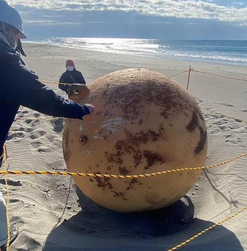
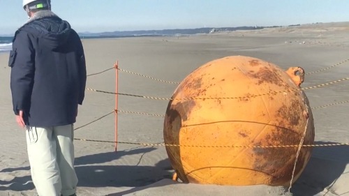
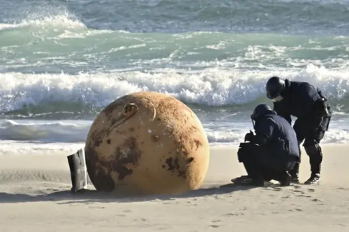
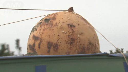
Sean bienvenidos japonítasarqueológicos, a una nueva novedad japonesa, que está dando la vuelta al mundo una vez dicho esto póngase cómodos que empezamos. - Del día 21 al 23 de febrero, en la playa de Enshu el distrito de Nishi, en la ciudad de Hamamatsu en la prefectura de Shizuoka. - La bola de hierro mide 1’5 metros de diámetro, el Interior es hueco por lo que no hay riesgo de explotar. - Espero que os haya gustado¿Qué opinan ustedes? Abro el debate, nos vemos en próximas publicaciones de Japón. - ようこそ 日本の考古学者の皆さん 世界に羽ばたく日本の新機軸をご覧ください と言うわけで 楽にしてください 始めましょう - 2月21日から23日まで、静岡県浜松市西区にある遠州灘海岸にて。 - 鉄球は直径1.5メートル、内部は空洞で爆発の心配はない。 - いかがでしたか、いかがでしたか。また、日本からの投稿でお会いしましょう。 - Welcome, Japanese archaeologists, to a new Japanese novelty, which is making its way around the world, and with that said, make yourselves comfortable and let's get started. - From the 21st to the 23rd of February, at Enshu Beach, Nishi District, Hamamatsu City, Shizuoka Prefecture. - The iron ball is 1.5 metres in diameter, the interior is hollow so there is no risk of exploding. - I hope you liked it. What do you think? I open the debate, see you in future posts from Japan.
Tour the Ocean through the Art of Sound
The ocean is one of the largest ecosystems on our planet. From eye-catching waves to the darkness of the twilight zone, it’s a place filled with mystery and rapid change.

For a scientist studying ocean color at NASA’s Goddard Space Flight Center in Greenbelt, Maryland, there was one more question–what does it sound like?
Before long, a “symphonic ocean experience” was born, combining satellite imagery, ocean color data and programming expertise. Learn more about how data gets converted to music and sound here:
This World Oceans Day, enjoy a tour of the ocean set to sound. Here we go:

Bering Sea
This melody explores the phytoplankton blooms in the western Bering Sea along the coast of the Kamchatka Peninsula collected by Aqua/MODIS on May 15, 2021. The melody created for this image was aimed at capturing the movement of the eddies or the circular movements of water. Data came from the image’s red, green, and blue channels.
Rio de la Plata
This melody explores a spring bloom in the South Atlantic Ocean off the coast of Argentina, Uruguay, and Brazil, lending the water many different shades of green, blue, and brown. The Rio de la Plata estuary in the northwest corner of the above image gets most of its tan coloration from sediments suspended in the water. The melody paired with the data evokes the sediment plumes and swirls happening off the coast.
Coral Sea
Data for the sounds of the Coral Sea were collected over the course of one year from the Aqua/Modis satellite. The information was extracted from a series of 32-day rolling averages for the year 2020, displaying the movement of chlorophyll a data.
Chlorophyll a is a specific form of chlorophyll used in photosynthesis. It absorbs most energy from wavelengths of violet-blue and orange-red light. It is a poor absorber of green and near-green portions of the spectrum, and that’s why it appears green.
Western Australia
Off the coast of western Australia is the appearance of swirls in the ocean. To catch the movement of the Indian Ocean, data was collected from 31 days of imagery examining blue wavelengths of light. The information was gathered from the Suomi-NPP/VIIRS instrument aboard the Joint Polar Satellite System (JPSS) series of spacecraft.
More moments of zen
Looking for more moments of zen? Explore them with NASA’s Soundcloud page, where many are out of this world. Curious on how we get these breathtaking ocean images? Take time to read about Goddard Oceanographer Norman Kuring and how he helped create them.
This past weekend marked the first anniversary of the launch of NASA’s latest ocean color satellite, PACE 🛰️! Happy birthday PACE!

Sharpening Our View of Climate Change with the Plankton, Aerosol, Cloud, ocean Ecosystem Satellite
As our planet warms, Earth’s ocean and atmosphere are changing.
Climate change has a lot of impact on the ocean, from sea level rise to marine heat waves to a loss of biodiversity. Meanwhile, greenhouse gases like carbon dioxide continue to warm our atmosphere.
NASA’s upcoming satellite, PACE, is soon to be on the case!
Set to launch on Feb. 6, 2024, the Plankton, Aerosol, Cloud, ocean Ecosystem (PACE) mission will help us better understand the complex systems driving the global changes that come with a warming climate.

Earth’s ocean is becoming greener due to climate change. PACE will see the ocean in more hues than ever before.
While a single phytoplankton typically can’t be seen with the naked eye, communities of trillions of phytoplankton, called blooms, can be seen from space. Blooms often take on a greenish tinge due to the pigments that phytoplankton (similar to plants on land) use to make energy through photosynthesis.
In a 2023 study, scientists found that portions of the ocean had turned greener because there were more chlorophyll-carrying phytoplankton. PACE has a hyperspectral sensor, the Ocean Color Instrument (OCI), that will be able to discern subtle shifts in hue. This will allow scientists to monitor changes in phytoplankton communities and ocean health overall due to climate change.

Phytoplankton play a key role in helping the ocean absorb carbon from the atmosphere. PACE will identify different phytoplankton species from space.
With PACE, scientists will be able to tell what phytoplankton communities are present – from space! Before, this could only be done by analyzing a sample of seawater.
Telling “who’s who” in a phytoplankton bloom is key because different phytoplankton play vastly different roles in aquatic ecosystems. They can fuel the food chain and draw down carbon dioxide from the atmosphere to photosynthesize. Some phytoplankton populations capture carbon as they die and sink to the deep ocean; others release the gas back into the atmosphere as they decay near the surface.
Studying these teeny tiny critters from space will help scientists learn how and where phytoplankton are affected by climate change, and how changes in these communities may affect other creatures and ocean ecosystems.

Climate models are one of our most powerful tools to understand how Earth is changing. PACE data will improve the data these models rely on.
The PACE mission will offer important insights on airborne particles of sea salt, smoke, human-made pollutants, and dust – collectively called aerosols – by observing how they interact with light.
With two instruments called polarimeters, SPEXone and HARP2, PACE will allow scientists to measure the size, composition, and abundance of these microscopic particles in our atmosphere. This information is crucial to figuring out how climate and air quality are changing.
PACE data will help scientists answer key climate questions, like how aerosols affect cloud formation or how ice clouds and liquid clouds differ.
It will also enable scientists to examine one of the trickiest components of climate change to model: how clouds and aerosols interact. Once PACE is operational, scientists can replace the estimates currently used to fill data gaps in climate models with measurements from the new satellite.

With a view of the whole planet every two days, PACE will track both microscopic organisms in the ocean and microscopic particles in the atmosphere. PACE’s unique view will help us learn more about the ways climate change is impacting our planet’s ocean and atmosphere.
Stay up to date on the NASA PACE blog, and make sure to follow us on Tumblr for your regular dose of sPACE!
Next month will be the one year anniversary of the PACE launch!
Sharpening Our View of Climate Change with the Plankton, Aerosol, Cloud, ocean Ecosystem Satellite
As our planet warms, Earth’s ocean and atmosphere are changing.
Climate change has a lot of impact on the ocean, from sea level rise to marine heat waves to a loss of biodiversity. Meanwhile, greenhouse gases like carbon dioxide continue to warm our atmosphere.
NASA’s upcoming satellite, PACE, is soon to be on the case!
Set to launch on Feb. 6, 2024, the Plankton, Aerosol, Cloud, ocean Ecosystem (PACE) mission will help us better understand the complex systems driving the global changes that come with a warming climate.
Earth’s ocean is becoming greener due to climate change. PACE will see the ocean in more hues than ever before.
While a single phytoplankton typically can’t be seen with the naked eye, communities of trillions of phytoplankton, called blooms, can be seen from space. Blooms often take on a greenish tinge due to the pigments that phytoplankton (similar to plants on land) use to make energy through photosynthesis.
In a 2023 study, scientists found that portions of the ocean had turned greener because there were more chlorophyll-carrying phytoplankton. PACE has a hyperspectral sensor, the Ocean Color Instrument (OCI), that will be able to discern subtle shifts in hue. This will allow scientists to monitor changes in phytoplankton communities and ocean health overall due to climate change.
Phytoplankton play a key role in helping the ocean absorb carbon from the atmosphere. PACE will identify different phytoplankton species from space.
With PACE, scientists will be able to tell what phytoplankton communities are present – from space! Before, this could only be done by analyzing a sample of seawater.
Telling “who’s who” in a phytoplankton bloom is key because different phytoplankton play vastly different roles in aquatic ecosystems. They can fuel the food chain and draw down carbon dioxide from the atmosphere to photosynthesize. Some phytoplankton populations capture carbon as they die and sink to the deep ocean; others release the gas back into the atmosphere as they decay near the surface.
Studying these teeny tiny critters from space will help scientists learn how and where phytoplankton are affected by climate change, and how changes in these communities may affect other creatures and ocean ecosystems.
Climate models are one of our most powerful tools to understand how Earth is changing. PACE data will improve the data these models rely on.
The PACE mission will offer important insights on airborne particles of sea salt, smoke, human-made pollutants, and dust – collectively called aerosols – by observing how they interact with light.
With two instruments called polarimeters, SPEXone and HARP2, PACE will allow scientists to measure the size, composition, and abundance of these microscopic particles in our atmosphere. This information is crucial to figuring out how climate and air quality are changing.
PACE data will help scientists answer key climate questions, like how aerosols affect cloud formation or how ice clouds and liquid clouds differ.
It will also enable scientists to examine one of the trickiest components of climate change to model: how clouds and aerosols interact. Once PACE is operational, scientists can replace the estimates currently used to fill data gaps in climate models with measurements from the new satellite.
With a view of the whole planet every two days, PACE will track both microscopic organisms in the ocean and microscopic particles in the atmosphere. PACE’s unique view will help us learn more about the ways climate change is impacting our planet’s ocean and atmosphere.
Stay up to date on the NASA PACE blog, and make sure to follow us on Tumblr for your regular dose of sPACE!
Diatoms: Algae in glass houses
Check out my new post!
http://becausephytoplankton.blogspot.com/2018/09/diatoms-algae-in-glass-houses.html
Very cool. My lab group also works with Emiliania huxleyi and EhVs.
Packing for a Journey into the Twilight Zone
Submitted for your consideration: A team of researchers from more than 20 institutions, boarding two research vessels, heading into the ocean’s twilight zone.
The twilight zone is a dimly lit region between 650 and 3300 feet below the surface, where we’re unfolding the mystery of how tiny ocean organisms affect our planet’s climate.

These tiny organisms – called phytoplankton – are plant-like and mostly single-celled. They live in water, taking in carbon dioxide and releasing oxygen.

Two boats, more than 100 researchers from more than 20 partner institutions, and a whole fleet of robotic explorers make up the EXport Processes in the Ocean from RemoTe Sensing (EXPORTS) team. We’re learning more about what happens to carbon dioxide after phytoplankton digest it.

The Equipment to Find Phytoplankton

Phytoplankton have predators in the ocean called zooplankton. They absorb the phytoplankton’s carbon, carrying it up the food chain. The EXPORTS mission will focus partly on how that happens in the ocean’s twilight zone, where some zooplankton live. When phytoplankton die, sometimes their bodies sink through the same area. All of this carries carbon dioxide into the ocean’s depths and out of Earth’s atmosphere.

Counting Life
Studying the diversity of these organisms is important to better understand what’s happening to the phytoplankton as they die. Researchers from the Virginia Institute of Marine Science are using a very fine mesh net to sample water at various depths throughout the ocean to count various plankton populations.

Researchers from the University of Rhode Island are bringing the tools to sequence the DNA of phytoplankton and zooplankton to help count these organism populations, getting a closer look at what lives below the ocean’s surface.

Science at 500 Feet
Taking measurements at various depths is important, because phytoplankton, like plants, use sunlight to digest carbon dioxide. That means that phytoplankton at different levels in the ocean absorb and digest carbon differently. We’re bringing a Wirewalker, an instrument that glides up and down along a vertical wire to take in water samples all along its 500-foot long tether.

This journey to the twilight zone will take about thirty days, but we’ll be sending back dispatches from the ships. Follow along as we dive into ocean diversity on our Earth Expeditions blog: https://blogs.nasa.gov/earthexpeditions.
Make sure to follow us on Tumblr for your regular dose of space: http://nasa.tumblr.com.
You know the existence of rogue waves is deeply upsetting to me like what do you mean they can justdecide to be 50 feet tall?? No prompting(that we know of) one wave just decides to be that tall and there isn’t anything we can do about it? It’s fucked up really.


HEY JUDE! Ceratias tentaculatus
original illustration in “Fishes of the Southern Ocean”

LEARNING TO FLY but I ain´t got wings
Borostomias antarcticus original illustration in Fishes of the Southern Ocean

