Satellite - Blog Posts
Spain Launches Its First Military Satellite: A Leap Forward in Space Technology*
On January 30th, Spain marked a historic milestone with the successful launch of its first military satellite, SPAINSAT NG 1. The satellite was launched from Cape Canaveral aboard a SpaceX Falcon 9 rocket and is now positioned in geostationary orbit, approximately 35,786 kilometers above Earth—nearly three times the planet's diameter.

Operated by the Spanish company Hisdesat, SPAINSAT NG 1 is hailed as the most advanced satellite in Spain and the first in Europe equipped with cutting-edge technology antennas. This innovation includes X-band antennas and beam-hopping technology, enabling the satellite to redirect electronic signals without physical movement. Additionally, it boasts the ability to detect and neutralize interference on Earth, ensuring secure communications for Spanish military forces and NATO.
The satellite is expected to remain operational until 2037, providing reliable and secure communication capabilities. Looking ahead, its twin satellite, SPAINSAT NG II, is scheduled for launch around September or October 2025. Together, these satellites will cover two-thirds of the planet, securing communications from Denmark to Singapore.
This achievement underscores Spain's growing presence in the space sector and its commitment to advancing technological innovation.
Turns out I’ve been on this website for two years now. How exciting! And even better now that it’s happening right as we’re getting our first images from the James Webb Space Telescope. Looking from Earth, this image is from a point in space smaller than a grain of sand. And look how many beautiful galaxies and stars are in this incredible photo. I look forward to many more incredible pictures, and more discoveries about the wondrous void 🪐 🔭

via NASA, James Webb infrared deep dive
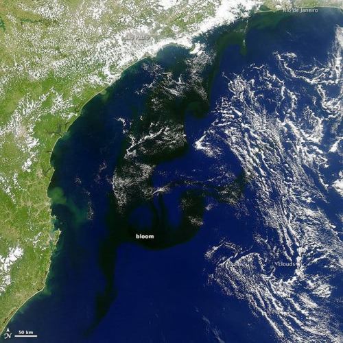
Covering the oceans in darkness….
Phytoplankton blooms produce some fascinating textures in Earth’s oceans, and consequently we’ve shared images of them taken from orbit many times (http://tinyurl.com/qhzwbr9, http://tinyurl.com/pwasxol). This bloom, however is a bit different from the others – in this photo from NASA’s Aqua satellite, it looks, well, black.
Keep reading
Some Solar_Power Satellites of The Future might be Solar_Powered Blimps that float around in The Stratosphere.

Solar-Powered Blimps Are the New Satellites

AVIATION INDUSTRY FLIES HIGHER WITH GEOSPATIAL DATA

Currently, the amount of technological advancement that the world is witnessing is astounding. An essential part of this development is the growth of the drone and the aviation industry. Drones are getting more often used for surveillance, photography, deliveries, etc. As drone applications increase, the drone industry turns to satellite imagery and geospatial data to optimize its planning, operations, maintenance, and security efforts. To the same extent, planning and managing autonomous flights – manned or unmanned- is making huge steps forward.
Drones for Factory Surveillance
More and more industries are relying on drones for factory surveillance. Drones help the factories monitor real-time activities at any time of the day or night while sitting in any corner of the world. The main advantages of using drones instead of traditional factory surveillance methods are their dynamic placement, the bird's eye view that they can provide, and continuous situational awareness. Factory surveillance through drone technology is much more feasible in terms of costs and ease of use.
Drone Taxis
As shown in sci-fi movies, drones have become a reality for transporting people as a private vehicle and a part of a public transport system. Drones have many advantages over heavy-weight airplanes, especially for short distances and, for example, in Urban Air Mobility (UAM), representing a very challenging environment.
The lighter weight of drones makes them more maneuverable in flight and landing. Drone taxis can fly at low altitudes, and with proper maneuvering, they can be easily saved from running into obstacles. Satellite imagery can help in the easy detection of obstacles. With the concept of travel by drone not yet becoming popular, there is no chance of traffic congestion in the airspace currently. Even when the situation changes, satellite data can primarily help in drone traffic management.
With the rise in drone usage, their safe flight planning and management becomes even more critical, and this is where satellite data can play an unmatched role.
Safer Autonomous Flying with remote sensing
A requirement for safe autonomous flying is up-to-date and precise data regarding obstacles and potential landing spots, integrated into flight planning and operations. Digital Surface Models (DSM) with clutter information and high-resolution satellite imagery can be essential sources.
Remote sensing enables drone operators to prepare a flight plan by providing broader information coverage than traditionally surveyed.
Remote sensing can help provide information about building locations and other obstacles that can hamper and endanger drone operations within a particular area. Using LiDAR, you can have highly accurate elevation data, which is critical for drone operations. Multispectral imagery can mainly help in assessing the natural environment around a drone's flight path. Information about trees that can grow to become obstructions, wetlands in potential construction areas, or vegetation that can attract birds are critical for safe drone flight operations. Satellite imagery can aid in getting a good understanding of such information.
Better Management of Air Traffic
Geospatial technology can play an essential role in controlling air traffic. Location data can enable drones to coordinate with each other and avoid collisions. This could aid in the easy rerouting of air traffic as necessary.
The trend of using satellite data for safer drone operations is picking up. For instance, Altitude Angel, the UTM (Unmanned Traffic Management) technology provider, and Inmarsat specializes in global mobile satellite communications, recently collaborated to develop and deliver an advanced flight tracking and management capability for drones.
The two companies intend to build on Altitude Angel's GuardianUTM platform and develop a 'Pop-Up UTM' capability, which can be deployed anywhere required to manage Beyond Visual Line of Sight (BVLOS) operations. Various other companies are working in parallel on similar projects.
Flying Beyond Visual Line of Sight (BVLOS) more safely
Beyond Visual Line of Sight (BVLOS) operation is picking up as a standard requirement in many industrial and mission-critical applications. Unlocking BVLOS operations in autonomous drones is creating new use cases and enhanced performance scenarios in various applications.
Be it disaster management, precision agriculture, law enforcement, or insurance, more and more industries consider BVLOS as the future for managing operations. For instance, the wide-area surveillance capability that BVLOS offers allows insurers to assess losses in disaster-stricken neighborhoods safely and quickly.
However, the deficit of confidence in the safe operation of BVLOS remains a critical hurdle on their path to getting more ubiquitously adopted. In the absence of a pilot's view, these drones face higher risks of collisions and accidents. This is where high-resolution satellite data can help. The drones can gain enhanced situational awareness using accurate satellite imagery, informing them about the obstacles and helping them reroute as and when necessary. High-resolution, up-to-date data leads to improved planning and increased situational awareness during the flight. This simplifies the process of mapping routes and finding appropriate landing spots.
Where to find high-quality Geodata for safe drone operations?
So, there remains no doubt that is using high-quality geospatial data. The drone and aviation industry can achieve a high operational excellence level in planning and managing flight operations. Geospatial data can also significantly aid in air traffic management and BVLOS operations.
However, an important question arises here: 'Where can I get high-quality geospatial data that meets these needs most effectively?'
One answer is cloudeo.
Using cloudeo, you can access multiple high-quality, ready-to-use data from various geodata creators like satellites, airplanes, drones, and in-situ-data under Data as a Service(DaaS) in a few clicks. Additionally, the Software as a Service (SaaS) feature can allow you to use the latest version of different software types needed to process the geodata without worrying about updates, releases, etc. The platform strategically brings together partners and customers into one standard operating platform globally.
This cloud-based market platform hosts a wide range of value-added service providers and developers who can simplify and customize the data as per the user's needs. With Infrastructure as a Service (IaaS) provision, the users can use all cloudeo services without increasing their IT infrastructure cost. The service works excellently with user-specific specifications, code, workflow, and even offers scalable options at a very affordable price at the customer's preferred location and time.
All in all, the platform stands out as the perfect choice for high-valued geoinformation services that the aviation industry is looking at for better operations. By bringing in all the data creators, data processors, and data users into one platform, cloudeo is creating the most user-friendly geospatial solutions marketplace to meet your company's need of accessing highly accurate geospatial data.
Explore cloudeo today and take an essential step towards building a safe drone flying environment.

International Asteroid Day aims to raise public awareness about the asteroid impact hazard and to inform the public about the crisis communication actions to be taken at the global level in case of a credible near-Earth object threat. . . . . . . #asteroid #universe #space #spacetime #astronomy #astronomer #spacestation #spacetravel #sunrise #satellite https://www.instagram.com/p/CCDuhL2DN0Z/?igshid=5vxzze8zzajg
These new type of satellites are revolutionizing how scientists will keep an eye on the Earth for years to come! Check out the CYGNSS one! :)
6 Tiny Satellites That Are Changing How We See Earth

HARP: Hyper-Angular Rainbow Polarimeter
What’s better than taking a picture of a cloud to figure out its size and shape? Taking a bunch of pictures all around it. That way you get a three-dimensional view without having to worry about missing something. The HARP CubeSat is going to do just that: make observations of cloud droplets and tiny airborne particles like soot and dust with a modified camera lens from multiple angles. This will give us a full rendering of what’s going on inside the clouds, specifically, how those airborne particles act as “seeds” for water vapor to condense on and form cloud droplets. Since so many of those particles are in the air as a result of man-made pollution, we want to understand how they may be affecting clouds, weather and climate.

RAVAN: Radiometer Assessment using Vertically Aligned Nanotubes
Anyone who’s worn a black shirt on a summer day knows how much sunlight and heat it absorbs. The RAVAN 3-unit CubeSat, however, carries “blacker than black” technology – carbon nanotubes set up like a bundle of drinking straws that suck up nearly all the sunlight and energy that reach them to the point that your black shirt seems merely dark grey in comparison. Flying in low Earth orbit, RAVAN’s super sensitive instrument will detect tiny changes in the amount of sunlight and energy passing into and out of the top of the atmosphere. The amount of energy passing through the top of the atmosphere is where the net accounting of Earth’s energy budget happens – one of the major measurements we need in order to understand the effects of greenhouse gases on global warming and climate change.

MiRaTA: Microwave Radiometer Technology Acceleration
That long skinny piece coming out of the bottom right side under the solar panel? That’s a measuring tape. It’s doubling as a communications antenna on the MiRaTA CubeSat that will be a mini-weather station in space. This 3-unit, shoe box-sized satellite is testing out new, miniaturized technology to measure temperature, water vapor, and cloud ice in the atmosphere. They’ll be tracking major storms, including hurricanes, as well as everyday weather. If this test flight is successful, the new, smaller technology will likely be incorporated into major – large – weather satellite missions in the future that are part of our national infrastructure.

IceCube
The aptly named IceCube will measure – you guessed it – ice in our atmosphere. Unlike the droplets that make up rain, ice is one of the harder things to measure from space. IceCube is a 3-unit CubeSat about the size of a loaf of bread outfitted with a new high-frequency microwave radiometer, an instrument that measures naturally occurring radiation emitted by stuff in the atmosphere – cloud droplets, rain, and the ice particles at the tops of clouds. This will be the first space test of the new microwave radiometer that has to balance its tiny size and low power with being sensitive enough to detect cloud ice.

CYGNSS: Cyclone, Global Navigation Satellite System
What do GPS signals do when they’re not talking to your phone? A lot of them are just bouncing harmlessly off the planet’s surface – a fact that the CYGNSS mission is taking advantage of to measure wind speed over the ocean. Eight identical small satellites, each about the size of a microwave oven, flying in formation carry custom modified GPS receivers pointed at the oceans. When the water is smooth – not windy – the GPS signals reflect back uniformly, like the moon on a pond reflected as if in a mirror. When the water is choppy – windy – the signals reflect back in in the same direction but distorted, like the moon reflection on a choppy pond being distorted by ripples. Flying eight satellites in formation means the CYGNSS mission can measure wind speed across more of the ocean at once, which will help with understanding tropical storms and hurricanes.

TROPICS: Time-Resolved Observations of Precipitation structure and storm Intensity with a Constellation of Smallsats
An important way to improve forecasts of hurricane and tropical cyclone intensity is to see what’s going on inside and around them while they’re happening. That’s the goal of the TROPICS mission, 12 CubeSats that will fly in formation to track the temperature and humidity of storm environments. The TROPICS CubeSats will get very frequent measurements, similar to X-rays, that cut through the overall cloud-cover so we can see the storm’s underlying structure. The storm structures known as the eyewall – tall clouds, wind and rain around the eye – and rainbands – the rainy parts of the spiral arms – give us clues about whether a storm is primed to intensify into a category 4 or 5 storm, something everyone in their path needs to know.
Learn more the world of small satellites at: https://www.nasa.gov/mission_pages/smallsats
Make sure to follow us on Tumblr for your regular dose of space: http://nasa.tumblr.com
So exciting!! GOES-R scheduled for launch today (11/19) at 542 PM EST. Great new technology, improved imagery, MORE imagery, NEW total lightning detection, and much more. Learn more about GOES-R by visiting www.goes-r.gov .
You can watch the launch on NASA TV. Check your local cable/satellite provider or you can watch online through USTREAM or via nasa.gov ‘s NASA TV website. Enjoy!

READY FOR LAUNCH: CU BOULDER INSTRUMENT SUITE TO ASSESS SPACE WEATHER
A multimillion dollar University of Colorado Boulder instrument package expected to help scientists better understand potentially damaging space weather is now slated to launch aboard a National Oceanic and Atmospheric Administration satellite on Saturday, Nov. 19.
Designed and built by CU Boulder’s Laboratory for Atmospheric and Space Physics (LASP), the instrument suite known as the Extreme Ultraviolet and X-ray Irradiance Sensors (EXIS) is the first of four identical packages that will fly on four NOAA weather satellites in the coming decade. EXIS will measure energy output from the Sun that can affect satellite operations, telecommunications, GPS navigation and power grids on Earth as part of NOAA’s next-generation Geostationary Operational Environmental Satellites-R Series (GOES-R).
“We are ready for launch and are looking forward to a successful mission,” said LASP Senior Research Scientist Frank Eparvier, principal investigator on the EXIS project. “These extremely sensitive instruments will help scientists better understand solar events and help to mitigate the effects of space weather on Earth.”
NASA’s contract with CU Boulder on behalf of NOAA to design, build, test, deliver and scientifically support the four instrument packages is for roughly $105 million. The GOES-R satellite was built by Lockheed Martin Space Systems Co. in Littleton, Colorado and will be launched on an Atlas V rocket built by United Launch Alliance, headquartered in Centennial, Colorado.
EXIS consists of two LASP instruments, including XRS, an X-ray sensor that can determine the strength of solar flares and provide rapid alerts to scientists, said Eparvier. Large solar flares, equivalent to the explosion of millions of atomic bombs, can trigger “proton events” that send charged atomic particles flying off the Sun and into Earth’s atmosphere in just minutes. They can damage satellites, trigger radio blackouts and even threaten the health of astronauts by penetrating spacecraft shielding, he said.
“The XRS gives the first alert that a solar flare is occurring, providing NOAA with details on its timing, magnitude and direction within seconds,” said Eparvier.
The second EXIS instrument, EUVS, will monitor solar output in the extreme ultraviolet portion of the electromagnetic spectrum, which is completely absorbed by Earth’s upper atmosphere, said Eparvier. When the extreme UV light wavelengths penetrate the upper atmosphere during active periods on the Sun, they can break apart, ionize and change the properties of the atmosphere through which satellites fly and radio waves propagate.
Fluctuations in extreme UV wavelengths from the Sun ionize the upper atmosphere and interfere with communications like cell phones and GPS signals, said Eparvier. In addition, such fluctuations can create satellite drag, causing spacecraft to slowly fall out of orbit and burn up months or years before such events are anticipated.
“Modern technology has made us vulnerable to extreme variations in space weather that can have significant effects on Earth communications,” Eparvier said. “Extreme solar activity can cause problems for power companies all around the world, for example, in part because they all are interconnected.”
NOAA’s GOES satellites are a series of weather satellites that help scientists make timely and accurate weather forecasts. Two GOES satellites are now in geostationary orbit at a height of about 22,000 miles, with one focusing on the east part of the Americas overlapping with another focusing on the west. Satellites in geostationary orbits complete one revolution in the same amount of time it takes for the Earth to rotate once on its polar axis, allowing them to “stare” at a portion of Earth, said Eparvier.
LASP also built key solar instruments for NASA’s Van Allen Probes mission launched in 2012 to study Earth’s radiation belts, and designed and built a $32 million instrument package for NASA’s Solar Dynamics Observatory that launched in 2010.
More than 100 LASP personnel ranging from scientists and engineers to technicians, programmers and students have worked on the EXIS program since 2006. CU Boulder’s LASP will support EXIS on the four NOAA GOES satellite missions through spacecraft integration, testing, launch and commissioning, said Eparvier.
Each instrument package, roughly the size of a large microwave oven and weighing 66 pounds, is three times heavier than normal due to extra shielding that protects them from high-energy particle penetration. LASP’s Mike Anfinson is the EXIS project manager.


- I Hear Everything-

Falcon 9 Sticks the Landing
Game changing launch of Iridium Next mission, Land of Falcon 9 first stage landing and deployment of 10 satellites in low earth orbit by SpaceX. These satellites will provide important data to first responders on Earth. The first stage landing was captured entirely by the Falcon 9's point of view. First launch following SpaceX's 2016 explosion. SpaceX worked with NASA, Airforce and other groups to identify the cause and find a solution. The 2016 was caused by carbon dioxide build up between stage 2's layer of aluminum and carbon fiber wrap.

Stage one successfully lands on barge named “Just Read the Instructions”.

Stage carrying the Iridium Next satellites glows red.

Liftoff with critical small one minute launch window.

Falcon 9′s fins adjust for landing on sea barge.
Help a fellow NASA Intern send a satellite into space!
Giveaway and Satellite Crowd Funder!
Giveaway/raffle, WIN a FREE telescope! We will select one winner and give away a Celestron 21035 70mm Travel Scope: And help support our effort launch a satellite!

To enter the UGA Small Satellite Research Lab’s giveaway all you have to do is:
Reblog this post (so we can get your name)
Liking the post will enter you a second time!
Following the small sat lab on tumblr will enter you a third time!
Following the small sat lab on twitter will enter your a fourth time (just tweet your us tumblr user name at us and tell us how cool you think space exploration is)!
Help Our Crowdfunded to build a spacecraft! Help us build a spacecraft!
We’re Crowdfunding a satellite! Donate at SmallSat.uga.edu/donate!
We’ll be sending a Satellite to the international Space Station in 2018! We just need help building the ground station!

The Donation Rewards:
If you have donated larger amount you will also get all the benefits of the lesser amounts! Be sure when you visit smallsat.uga.edu/donate that you include your information so that we can get in contact with you!
$5 - You will entered in the telescope raffle 2 more times and will receive a signed thank you card in the mail from the lab!
$10 - You will receive a signed certificate of space exploration from the UGA Small Satellite Research Laboratory
$25 - You will receive a mission patch of your choosing (our NASA patch has yet to be designed but the MOCI patch is below)
$50 - You will receive both mission patches!
$100 - We will give you a UGA Small Satellite Laboratory tee-shirt! Special made for supporters of our campaign!
$250 - We will tweet at you from space! once a month! (or you can control the message that you send!)
$500 - You will receive a plaque commemorating your participation in the development of our spacecraft!
$1000 - We will engrave your name on the side of our satellite!
Remember, you get ALL of the benefits of lower donations if you donate a higher one!
Please Help Us Out! We are partnered with NASA and will be sending a satellite to the International Space Station in 2018, but we do not have the money to build a ground station yet!
We have 2 3U cube satellites! The image below is the patch for our Mapping and Ocean Color Imager (MOCI). We are also building the SPectroscopic Observatory of Coastal regions (SPOC), is this is the satellite that will be launched to the International Space Station!
Donate At: SmallSat.uga.edu/donate!

The Crowdfunded and raffle end on July 31, 2016, after that it will take us 20-30 days to send out all the rewards! Donate at smallsat.uga.edu/donate! Feel free to message us or ask us any space questions you may have!
Donate At: SmallSat.uga.edu/donate!
One of the renderings of our satellite:


NASA'S KENNEDY SPACE CENTRE 🚀